IMAGES TAKEN NEAR TO
Vale Square, RAMSGATE, CT11 9DE
Introduction
This page details the photographs taken nearby to Vale Square, CT11 9DE by members of the Geograph project.
The Geograph project started in 2005 with the aim of publishing, organising and preserving representative images for every square kilometre of Great Britain, Ireland and the Isle of Man.

There are currently over 7.5m images from over14,400 individuals and you can help contribute to the project by visiting https://www.geograph.org.uk
Image Map
Images are licensed for reuse under creativecommons.org/licenses/by-sa/2.0
Notes
- Clicking on the map will re-center to the selected point.
- The higher the marker number, the further away the image location is from the centre of the postcode.
Image Listing (174 Images Found)
Images are licensed for reuse under creativecommons.org/licenses/by-sa/2.0
Image
Details
Distance
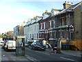
1
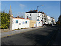
Renovation of 8, Crescent Road
Even though the entrance to the house appears to be in Vale Road, this address has been affixed to the pillar to the left of the front gate.
Image: © John Baker
Taken: 23 Oct 2016
0.05 miles
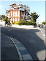
4
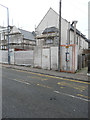
Hoarding, 69, West Cliff Road
The Image, behind the hoarding, has been sold by Miles and Barr, who have an estate agency at 51, Queen Street, Ramsgate. Planning permission has been granted by Thanet District Council under application number F/TH/11/0096 for the “erection of 8 dwellings with access leading into West Cliff Road. The location was given as 69 West Cliff Road.
Image: © John Baker
Taken: 23 Oct 2016
0.07 miles
5
Houses under construction, 69, West Cliff Road
Planning permission was granted by Thanet District Council under application number F/TH/11/0096 for the “erection of 8 dwellings with access leading into West Cliff Road. This image of the Image shows the houses, which were being built behind these.
Image: © John Baker
Taken: 31 Dec 2017
0.07 miles
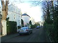
6
69, West Cliff Road
The houses have been numbered from 1-8. These are the Image
Image: © John Baker
Taken: 19 Aug 2018
0.07 miles
7

Erection of houses, 69, West Cliff Road
My previous image of this location described as a Image showed what lay beyond the hoarding, as part had been removed. Planning permission was granted by Thanet District Council under application number F/TH/11/0096 for the “erection of 8 dwellings with access leading into West Cliff Road. The location was given as 69 West Cliff Road. This development can also be seen in the view of Image taken in October 2016.
Image: © John Baker
Taken: 23 Apr 2017
0.07 miles

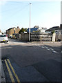
9
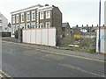
Derelict plot of land, 69, West Cliff Road
Planning permission has been granted by Thanet District Council under application number F/TH/11/0096 for the “erection of 8 dwellings with access leading into West Cliff Road. The location was given as 69 West Cliff Road.
Image: © John Baker
Taken: 9 Nov 2014
0.08 miles