IMAGES TAKEN NEAR TO
Ethelbert Road, RAMSGATE, CT11 9BL
Introduction
This page details the photographs taken nearby to Ethelbert Road, CT11 9BL by members of the Geograph project.
The Geograph project started in 2005 with the aim of publishing, organising and preserving representative images for every square kilometre of Great Britain, Ireland and the Isle of Man.

There are currently over 7.5m images from over14,400 individuals and you can help contribute to the project by visiting https://www.geograph.org.uk
Image Map
Images are licensed for reuse under creativecommons.org/licenses/by-sa/2.0
Notes
- Clicking on the map will re-center to the selected point.
- The higher the marker number, the further away the image location is from the centre of the postcode.
Image Listing (300 Images Found)
Images are licensed for reuse under creativecommons.org/licenses/by-sa/2.0
Image
Details
Distance
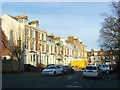
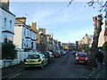
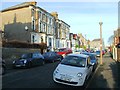
5
Clarendon Gardens, Ramsgate
The west end of Clarendon Gardens, seen from Elms Avenue.
Image: © Richard Vince
Taken: 24 Aug 2012
0.04 miles
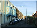
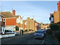
8

Renovation of Chatham & Clarendon Grammar School
The school, also known as Clarendon House, is located in Clarendon Gardens.
Image: © John Baker
Taken: 2 Jan 2017
0.05 miles