IMAGES TAKEN NEAR TO
Elms Avenue, RAMSGATE, CT11 9BD
Introduction
This page details the photographs taken nearby to Elms Avenue, CT11 9BD by members of the Geograph project.
The Geograph project started in 2005 with the aim of publishing, organising and preserving representative images for every square kilometre of Great Britain, Ireland and the Isle of Man.

There are currently over 7.5m images from over14,400 individuals and you can help contribute to the project by visiting https://www.geograph.org.uk
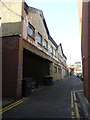
Image Map
Images are licensed for reuse under creativecommons.org/licenses/by-sa/2.0
Notes
- Clicking on the map will re-center to the selected point.
- The higher the marker number, the further away the image location is from the centre of the postcode.
Image Listing (465 Images Found)
Images are licensed for reuse under creativecommons.org/licenses/by-sa/2.0
Image
Details
Distance
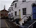
1

Renovation of Chatham & Clarendon Grammar School
The school, also known as Clarendon House, is located in Clarendon Gardens.
Image: © John Baker
Taken: 2 Jan 2017
0.02 miles
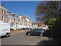
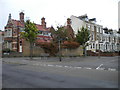
4
Guildford Lawn
A terrace of bow fronted houses built about 1842 by William Saxby. The background is closed by the frontage to the library designed by Stanley Davenport Adshead in 1904 in a ne-Georgian style. Nice and unusual survival of early 19th century ironwork along the frontage to the terrace.
Image: © Christopher Hall
Taken: 7 Mar 2012
0.05 miles
5
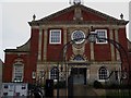
The Library
Detail of the frontage to the library designed by Stanley Davenport Adshead in 1904 in the neo-Georgian style. The railings, gates and lamp arch are by him too.
Image: © Christopher Hall
Taken: 7 Mar 2012
0.05 miles
6
1, Archway Road
Thanet District Council has granted permission under application number F/TH/13/0694 for the “change of use of building to provide eight 1-bed flats and three 2-bed flats, together with a roof extension for the second floor accommodation”. This side of the building is engraved with the words and number “established 1817 merchants”.
However this was superseded by the planning permission, which was granted by Thanet District Council under application number F/TH/17/0127 for the “erection of a 3-storey building containing 3 1-bed flats to side of 1 Archway Road following demolition of existing garage”.
Image: © John Baker
Taken: 23 Oct 2016
0.05 miles
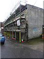
7
Demolition of 1, Archway Road
Planning permission was granted by Thanet District Council under application number F/TH/17/0127 for the “erection of a 3-storey building containing 3 1-bed flats to side of 1 Archway Road following demolition of existing garage”. This was the premises of Bown of London and this image shows Image before the scaffolding was erected.
Image: © John Baker
Taken: 31 Dec 2017
0.05 miles
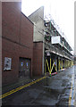
8
Flats, Archway Road
This was the Image in December 2017, after which the work of constructing the flats began.
Image: © John Baker
Taken: 22 Mar 2020
0.05 miles
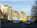
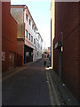
9
Clarendon Gardens, Ramsgate
The west end of Clarendon Gardens, seen from Elms Avenue.
Image: © Richard Vince
Taken: 24 Aug 2012
0.05 miles
10
Demolition of 1, Archway Road
Planning permission was granted by Thanet District Council under application number F/TH/17/0127 for the “erection of a 3-storey building containing 3 1-bed flats to side of 1 Archway Road following demolition of existing garage”. This was the premises of Bown of London.
Image: © John Baker
Taken: 31 Dec 2017
0.06 miles