IMAGES TAKEN NEAR TO
Packers Lane, RAMSGATE, CT11 8QA
Introduction
This page details the photographs taken nearby to Packers Lane, CT11 8QA by members of the Geograph project.
The Geograph project started in 2005 with the aim of publishing, organising and preserving representative images for every square kilometre of Great Britain, Ireland and the Isle of Man.

There are currently over 7.5m images from over14,400 individuals and you can help contribute to the project by visiting https://www.geograph.org.uk
Image Map
Images are licensed for reuse under creativecommons.org/licenses/by-sa/2.0
Notes
- Clicking on the map will re-center to the selected point.
- The higher the marker number, the further away the image location is from the centre of the postcode.
Image Listing (300 Images Found)
Images are licensed for reuse under creativecommons.org/licenses/by-sa/2.0
Image
Details
Distance
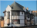
1
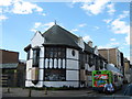
Braces, Ramsgate
Closed public house on the junction of Belmont Street (on the left) and King Street (on the right - with smoking cyclist!) .
Image: © David Anstiss
Taken: 8 May 2011
0.02 miles
2
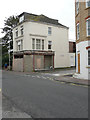
Looking west-southwest across King Street
Towards a building, on the corner of Sussex Street, whose ground floor renovation seems to have come to an end, for the moment. Only a fragment of the original signage is visible.
Image: © John Baker
Taken: 15 Sep 2015
0.03 miles
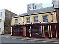
5
Braces, King Street
Closed pub at the junction Belmont Street.
Image: © Oast House Archive
Taken: 16 Oct 2011
0.04 miles
6
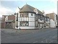
The former Braces public house, 98 King Street
It has also been known as Swiss Cottage, Duke’s and the Duke of Kent http://www.dover-kent.com/Pubs/Braces-Ramsgate.html
Image: © John Baker
Taken: 19 Nov 2013
0.04 miles
7
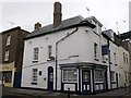
Maguires, Ramsgate
This pub on the junction of King Street (on the right) and Brunswick Street, was once the Chatham Arms.
It is a Grade II listed building. See http://www.britishlistedbuildings.co.uk/en-171872-chatham-arms-ramsgate-kent for more details about the building.
Image: © David Anstiss
Taken: 17 Feb 2014
0.04 miles
8
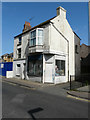
127 & 129, King Street
Number 129 is derelict and next to Image, while number 127 is a bookshop.
Image: © John Baker
Taken: 23 Apr 2017
0.04 miles
9
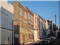
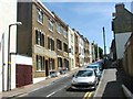
Artillery Road
Terraced residential hill.
Image: © Oast House Archive
Taken: 16 Oct 2011
0.04 miles
10
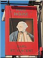
Earl St Vincent sign
Sign for a Image, a former Shepherd Neame pub on King Street, now free house. The old Shepherd Neame sign remains.
Image: © Oast House Archive
Taken: 16 Oct 2011
0.04 miles