IMAGES TAKEN NEAR TO
Newcastle Hill, RAMSGATE, CT11 8PQ
Introduction
This page details the photographs taken nearby to Newcastle Hill, CT11 8PQ by members of the Geograph project.
The Geograph project started in 2005 with the aim of publishing, organising and preserving representative images for every square kilometre of Great Britain, Ireland and the Isle of Man.

There are currently over 7.5m images from over14,400 individuals and you can help contribute to the project by visiting https://www.geograph.org.uk
Image Map
Images are licensed for reuse under creativecommons.org/licenses/by-sa/2.0
Notes
- Clicking on the map will re-center to the selected point.
- The higher the marker number, the further away the image location is from the centre of the postcode.
Image Listing (347 Images Found)
Images are licensed for reuse under creativecommons.org/licenses/by-sa/2.0
Image
Details
Distance
1
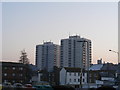
Kennedy House and Trove Court Ramsgate
Taken from Turner Street car park
Image: © PAUL FARMER
Taken: 10 Jan 2009
0.03 miles
3

Kennedy House and Trove Court
Kennedy House, right and Trove Court, left.
Image: © jamesunvala
Taken: 12 Feb 2007
0.04 miles

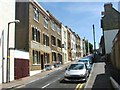
5
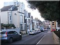
Artillery Road
Terraced residential hill.
Image: © Oast House Archive
Taken: 16 Oct 2011
0.04 miles
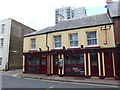
6

Earl St. Vincent, Public House, Ramsgate
Grade II Listed public house on King Street.
A former Shepherd Neame pub, now freehold.
See http://www.britishlistedbuildings.co.uk/en-171871-earl-st-vincent-99-and-101-ramsgate for more details on the building.
Image: © David Anstiss
Taken: 8 May 2011
0.04 miles
7

Earl St. Vincent, Pub Sign, Ramsgate
Outside Image
Pub was part of the Shepherd Neame brewery chain, now a free house.
Image: © David Anstiss
Taken: 8 May 2011
0.04 miles
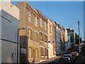
10
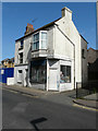
127 & 129, King Street
Number 129 is derelict and next to Image, while number 127 is a bookshop.
Image: © John Baker
Taken: 23 Apr 2017
0.05 miles