IMAGES TAKEN NEAR TO
Portland Court, RAMSGATE, CT11 8PL
Introduction
This page details the photographs taken nearby to Portland Court, CT11 8PL by members of the Geograph project.
The Geograph project started in 2005 with the aim of publishing, organising and preserving representative images for every square kilometre of Great Britain, Ireland and the Isle of Man.

There are currently over 7.5m images from over14,400 individuals and you can help contribute to the project by visiting https://www.geograph.org.uk
Image Map
Images are licensed for reuse under creativecommons.org/licenses/by-sa/2.0
Notes
- Clicking on the map will re-center to the selected point.
- The higher the marker number, the further away the image location is from the centre of the postcode.
Image Listing (182 Images Found)
Images are licensed for reuse under creativecommons.org/licenses/by-sa/2.0
Image
Details
Distance
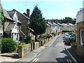
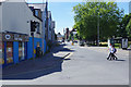
1
Looking southwest along King Street
Beyond Dave Fox Motorcycles was Collector’s Centre (which specialised in bric-a-brac, toys, stamps, medals and cards), whose frontage is now clad in scaffolding, which may indicate that the building is undergoing renovation before reopening under another name.
Image: © John Baker
Taken: 15 Sep 2015
0.01 miles
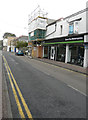
2
Looking west-southwest along King Street
Compared with Image, a new business has opened, beyond Dave Fox Motorcycles, under the name of Kings Antiques.
Image: © John Baker
Taken: 16 Feb 2016
0.01 miles
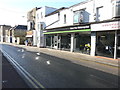
3
154 & 156, King Street
They have an air of being derelict, especially number 156, which has no tiles on its roof and a small tree growing in front of the first floor window.
Image: © John Baker
Taken: 15 Sep 2015
0.01 miles
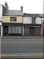
4
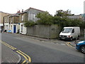
Looking west-southwest across King Street
Towards a derelict site on the corner of Portland Court.
Image: © John Baker
Taken: 15 Sep 2015
0.02 miles
5
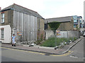
Derelict site, King Street
This is the same site as in the image of Image, where the boards and trees have been since removed.
Image: © John Baker
Taken: 19 Aug 2018
0.02 miles
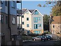
7
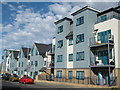
Modern town houses in Ramsgate
On Hardres Street.
On the site of former warehouse buildings.
Image: © David Anstiss
Taken: 8 May 2011
0.02 miles
8
Boundary Road, Ramsgate
Seen here from the junction with King Street and Hereson Road, Boundary Road forms a stretch of the A255. Friends Fish and Chip shop is on the left.
Image: © Stephen McKay
Taken: 4 Jul 2019
0.03 miles
9
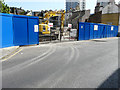
Site of former fuel depot, 131-137, King Street
Planning permission was granted (although prior approval was not required) by Thanet District Council under application number DM/TH/17/0037 for an “application for prior notification of proposed demolition of fuel depot”. It would appear that demolition is in progress. These views show the former fuel depot, which I described as Image and the Image from the WSW.
Image: © John Baker
Taken: 23 Apr 2017
0.04 miles