IMAGES TAKEN NEAR TO
La Belle Alliance Square, RAMSGATE, CT11 8HZ
Introduction
This page details the photographs taken nearby to La Belle Alliance Square, CT11 8HZ by members of the Geograph project.
The Geograph project started in 2005 with the aim of publishing, organising and preserving representative images for every square kilometre of Great Britain, Ireland and the Isle of Man.

There are currently over 7.5m images from over14,400 individuals and you can help contribute to the project by visiting https://www.geograph.org.uk
Image Map
Images are licensed for reuse under creativecommons.org/licenses/by-sa/2.0
Notes
- Clicking on the map will re-center to the selected point.
- The higher the marker number, the further away the image location is from the centre of the postcode.
Image Listing (639 Images Found)
Images are licensed for reuse under creativecommons.org/licenses/by-sa/2.0
Image
Details
Distance
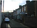
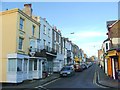
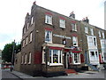
5
A terrace of houses in Plains of Waterloo
Waterloo Place is to the left. Looking towards Wellington Crescent and the sea.
Image: © pam fray
Taken: 2 Nov 2010
0.04 miles
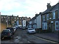
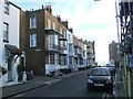
8
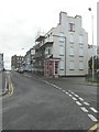
Looking south-southeast along Plains of Waterloo
The house on the right, with its frontage covered in scaffolding, is number 51. It appeared to be derelict, so the scaffolding may be acting as an aid to its refurbishment.
Image: © John Baker
Taken: 9 Nov 2014
0.04 miles