IMAGES TAKEN NEAR TO
Albion Hill, RAMSGATE, CT11 8HG
Introduction
This page details the photographs taken nearby to Albion Hill, CT11 8HG by members of the Geograph project.
The Geograph project started in 2005 with the aim of publishing, organising and preserving representative images for every square kilometre of Great Britain, Ireland and the Isle of Man.

There are currently over 7.5m images from over14,400 individuals and you can help contribute to the project by visiting https://www.geograph.org.uk
Image Map
Images are licensed for reuse under creativecommons.org/licenses/by-sa/2.0
Notes
- Clicking on the map will re-center to the selected point.
- The higher the marker number, the further away the image location is from the centre of the postcode.
Image Listing (677 Images Found)
Images are licensed for reuse under creativecommons.org/licenses/by-sa/2.0
Image
Details
Distance
2
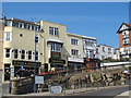
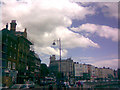
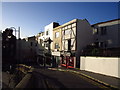
Madeira Walk, Ramsgate
The foot of Madeira Walk as it begins its winding ascent of Ramsgate's East Cliff, seen from the east end of Harbour Street.
Image: © Richard Vince
Taken: 24 Aug 2012
0.01 miles
3
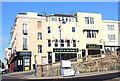
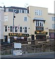
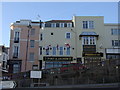
Port and Anchor
Now closed public house in Ramsgate.
Image: © Wayland Smith
Taken: 11 Nov 2012
0.01 miles
5
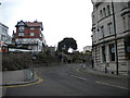
Road by the sea
This road (I think it's Westcliff Promenade or Military Road) is unusual for the Isle of Thanet as it runs directly beside the sea, with no beach between the two. What's more, it's the only road in the district that runs alongside a marina! View taken looking northeast, following the line of the sea out towards Broadstairs.
Image: © Robert Lamb
Taken: 5 Jul 2008
0.02 miles
6
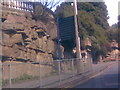
Interesting Pulhamite Formation on Madeira Walk
I don't know Ramsgate that well, so please correct me if I've got the location wrong. Anyhow, this is one of my favourite pictures. I love the colour of the Pulhamite (an imitation sandstone which, thanks to David Kemp's http://www.geograph.org.uk/photo/3222768 I am now able to give the proper name for it) and the way that it follows the line of the road - looks quite surreal, don't you think? A little further up the hill there is a small waterfall in the rocks, which I pictured on 5th July. This view is looking east up the hill towards Royal Parade.
Image: © Robert Lamb
Taken: 8 Apr 2008
0.02 miles
7
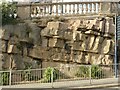
Pulhamite formation along Madeira Walk
The realistic nature of these artificial rock formations is very evident.
Image: © Alan Murray-Rust
Taken: 3 Sep 2022
0.02 miles
9
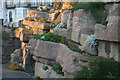
Madeira Walk, Ramsgate
Madeira Walk has been made to resemble a rocky gully by the use of Pulhamite, a man-made material invented by James Pulham (1820-98) of the firm James Pulham and Son of Broxbourne, Hertfordshire. Pulhamite, which usually looks like gritty sandstone often embedded with imitation fossils, was used to bond natural rocks and sundry rubble together or was crafted to simulate natural stone features. Its use at Ramsgate dates from 1894 and is far from uncommon in parks and public gardens elsewhere.
Image: © David Kemp
Taken: 11 Nov 2012
0.02 miles