IMAGES TAKEN NEAR TO
Kings Place, RAMSGATE, CT11 8FA
Introduction
This page details the photographs taken nearby to Kings Place, CT11 8FA by members of the Geograph project.
The Geograph project started in 2005 with the aim of publishing, organising and preserving representative images for every square kilometre of Great Britain, Ireland and the Isle of Man.

There are currently over 7.5m images from over14,400 individuals and you can help contribute to the project by visiting https://www.geograph.org.uk
Image Map
Images are licensed for reuse under creativecommons.org/licenses/by-sa/2.0
Notes
- Clicking on the map will re-center to the selected point.
- The higher the marker number, the further away the image location is from the centre of the postcode.
Image Listing (683 Images Found)
Images are licensed for reuse under creativecommons.org/licenses/by-sa/2.0
Image
Details
Distance
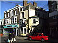
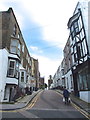
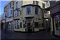
3
Bartlett and White, 11, King Street
The former greengrocer is permanently closed.
Image: © John Baker
Taken: 18 Apr 2021
0.01 miles
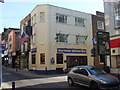
6
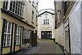
Kings Church, Ramsgate
Hidden along a side street.
Image: © Bill Boaden
Taken: 29 Jun 2012
0.01 miles
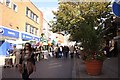
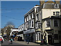
10
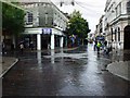
Ramsgate town centre
The crossroads where Queen Street, King Street, High Street and Harbour Street meet on a wet & miserable Tuesday lunchtime.
Image: © Phillip Perry
Taken: 23 Sep 2008
0.02 miles