IMAGES TAKEN NEAR TO
Winterstoke Way, RAMSGATE, CT11 8AG
Introduction
This page details the photographs taken nearby to Winterstoke Way, CT11 8AG by members of the Geograph project.
The Geograph project started in 2005 with the aim of publishing, organising and preserving representative images for every square kilometre of Great Britain, Ireland and the Isle of Man.

There are currently over 7.5m images from over14,400 individuals and you can help contribute to the project by visiting https://www.geograph.org.uk
Image Map
Images are licensed for reuse under creativecommons.org/licenses/by-sa/2.0
Notes
- Clicking on the map will re-center to the selected point.
- The higher the marker number, the further away the image location is from the centre of the postcode.
Image Listing (108 Images Found)
Images are licensed for reuse under creativecommons.org/licenses/by-sa/2.0
Image
Details
Distance
1
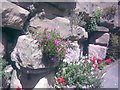
Close-up of Sandstone Wall in Ramsgate
I have pictured this sandstone wall in Ramsgate beforehand Image; however, I can now provide a close-up shot of it. As you can see, it is nicely decorated with flora, including geraniums and a purple flower which I am unsure about. However, the wall is not natural - if you look carefully, you may be able to see that the rocks are cemented together!
Image: © Robert Lamb
Taken: 5 Jul 2008
0.04 miles
3
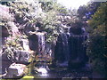
A Roadside Waterfall in Ramsgate
I am unsure of the exact location of this roadside waterfall - I am assuming its specified location by the shape of the road! The road curves and inclines upward from the marina, before curving back on itself and descending down to hotels on the seafront on the other side. The waterfall is made of sandstone, and despite the water being rather murky and teeming with scum, is quite attractive. View taken looking strictly north at the centre-left of the square.
Image: © Robert Lamb
Taken: 5 Jul 2008
0.08 miles
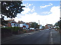
4
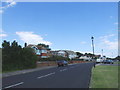
Two sea-facing houses, Victoria Parade
In August 2022, this location was a Image
Image: © John Baker
Taken: 5 Feb 2023
0.09 miles
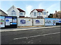
5
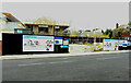
Building site, Victoria Parade
The words on the board affixed to the hoarding read: coming soon 2 sea facing detached homes.
Image: © John Baker
Taken: 14 Aug 2022
0.09 miles
7
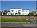
Four Winds Residential Care Home, Ramsgate
On Victoria Parade, with a fine view out to sea for those at the front.
Image: © Robin Webster
Taken: 29 Nov 2016
0.11 miles
8
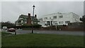
Different styles, Brockenhurst Road, Ramsgate
The house on the left is East Court [originally East Hill]. It was built in 1889-90 as a holiday home for a wealthy family and is Grade 2* listed. The building on the right is the former Four Winds residential care home. It was built in the 1930s and later extended.
Image: © Christine Johnstone
Taken: 15 Feb 2022
0.11 miles
9
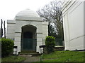
The Montefiore Mausoleum, Ramsgate
Situated next to the synagogue, Sir Moses Montefiore's wife, Judith, who died aged 78 in 1862, was buried here. Sir Moses had the mausoleum built over the grave. It is based on a structure on the road from Jerusalem to Bethlehem, said to be Rachel's tomb. He was buried alongside his wife when he died, aged 100, in 1885.
Image: © pam fray
Taken: 13 Mar 2012
0.12 miles
10
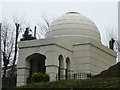
The Montefiore Mausoleum, Ramsgate
Situated next to the synagogue, Sir Moses Montefiore's wife, Judith,who died aged 78 in 1862, was buried here. Sir Moses had the mausoleum built over the grave. It is based on a structure on the road from Jerusalem to Bethlehem, said to be Rachel's tomb. He was buried alongside his wife when he died, aged 100, in 1885.
Image: © pam fray
Taken: 13 Mar 2012
0.12 miles