IMAGES TAKEN NEAR TO
Queens Gate Road, RAMSGATE, CT11 7RG
Introduction
This page details the photographs taken nearby to Queens Gate Road, CT11 7RG by members of the Geograph project.
The Geograph project started in 2005 with the aim of publishing, organising and preserving representative images for every square kilometre of Great Britain, Ireland and the Isle of Man.

There are currently over 7.5m images from over14,400 individuals and you can help contribute to the project by visiting https://www.geograph.org.uk
Image Map
Images are licensed for reuse under creativecommons.org/licenses/by-sa/2.0
Notes
- Clicking on the map will re-center to the selected point.
- The higher the marker number, the further away the image location is from the centre of the postcode.
Image Listing (134 Images Found)
Images are licensed for reuse under creativecommons.org/licenses/by-sa/2.0
Image
Details
Distance
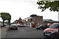
3
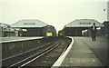
Trains meet at Ramsgate
Trains bound for Margate, Canterbury and Dover halt at Ramsgate station.
Image: © Roger Cornfoot
Taken: Unknown
0.07 miles
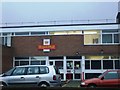
4
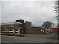
Ramsgate Royal Mail Sorting Office
On Wilfred Road.
Image: © David Anstiss
Taken: 6 Feb 2011
0.07 miles