IMAGES TAKEN NEAR TO
Boundary Road, RAMSGATE, CT11 7NR
Introduction
This page details the photographs taken nearby to Boundary Road, CT11 7NR by members of the Geograph project.
The Geograph project started in 2005 with the aim of publishing, organising and preserving representative images for every square kilometre of Great Britain, Ireland and the Isle of Man.

There are currently over 7.5m images from over14,400 individuals and you can help contribute to the project by visiting https://www.geograph.org.uk
Image Map
Images are licensed for reuse under creativecommons.org/licenses/by-sa/2.0
Notes
- Clicking on the map will re-center to the selected point.
- The higher the marker number, the further away the image location is from the centre of the postcode.
Image Listing (154 Images Found)
Images are licensed for reuse under creativecommons.org/licenses/by-sa/2.0
Image
Details
Distance
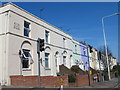
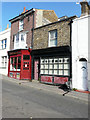
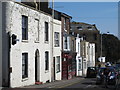
3
Terraced houses, Hollicondane Road, CT11
Image: © Mike Quinn
Taken: 23 Apr 2013
0.02 miles
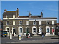
4
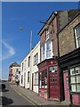
The East Kent Arms, Chatham Street, CT11
Image: © Mike Quinn
Taken: 23 Apr 2013
0.03 miles
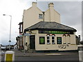
7
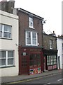
East Kent Arms, Ramsgate
On Chatham Street.
Image: © David Anstiss
Taken: 6 Feb 2011
0.03 miles
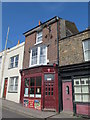
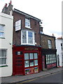
8
25, Chatham Street
Sandwiched between the East Kent Arms and number 23, the building looks as if it could have once been a shop.
Image: © John Baker
Taken: 23 Oct 2016
0.03 miles
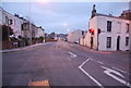
10
The Shakespeare pub, on Margate Road
On the junction of Hollicondane Road and Margate Road.
Image: © Nick Smith
Taken: 13 Dec 2009
0.04 miles