IMAGES TAKEN NEAR TO
Dane Park Road, RAMSGATE, CT11 7LR
Introduction
This page details the photographs taken nearby to Dane Park Road, CT11 7LR by members of the Geograph project.
The Geograph project started in 2005 with the aim of publishing, organising and preserving representative images for every square kilometre of Great Britain, Ireland and the Isle of Man.

There are currently over 7.5m images from over14,400 individuals and you can help contribute to the project by visiting https://www.geograph.org.uk
Image Map
Images are licensed for reuse under creativecommons.org/licenses/by-sa/2.0
Notes
- Clicking on the map will re-center to the selected point.
- The higher the marker number, the further away the image location is from the centre of the postcode.
Image Listing (63 Images Found)
Images are licensed for reuse under creativecommons.org/licenses/by-sa/2.0
Image
Details
Distance
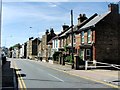
1
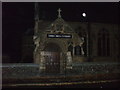
St Ethelbert's Catholic Primary School
On Dane Park Road.
Image: © David Anstiss
Taken: 17 Feb 2014
0.09 miles
2
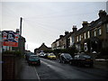
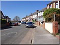
Cecilia Road, Ramsgate
The eastern end of Cecilia Road as it climbs away from Hereson Road.
Image: © Richard Vince
Taken: 24 Aug 2012
0.10 miles
4
St. Ethelbert's Church (2008), Ramsgate
Image: © Phillip Perry
Taken: 15 Oct 2008
0.12 miles
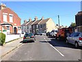
6
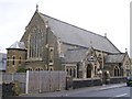
Catholic Church of St Ethelbert, Ramsgate
On Hereson Road.
Image: © David Anstiss
Taken: 17 Feb 2014
0.13 miles
7
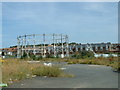
Disused Gas Works Site, Ramsgate
Situated on Boundary Road (A255).
Image: © John Smitten
Taken: 23 Jul 2004
0.13 miles
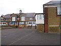
8
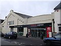
Tesco Express, Ramsgate
On Hereson Road.
Image: © David Anstiss
Taken: 17 Feb 2014
0.14 miles
9
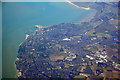
Thanet : Ramsgate Scenery
Looking down to the English coastline and Ramsgate.
Image: © Lewis Clarke
Taken: 18 Jun 2017
0.15 miles