IMAGES TAKEN NEAR TO
Vine Close, RAMSGATE, CT11 7BJ
Introduction
This page details the photographs taken nearby to Vine Close, CT11 7BJ by members of the Geograph project.
The Geograph project started in 2005 with the aim of publishing, organising and preserving representative images for every square kilometre of Great Britain, Ireland and the Isle of Man.

There are currently over 7.5m images from over14,400 individuals and you can help contribute to the project by visiting https://www.geograph.org.uk
Image Map
Images are licensed for reuse under creativecommons.org/licenses/by-sa/2.0
Notes
- Clicking on the map will re-center to the selected point.
- The higher the marker number, the further away the image location is from the centre of the postcode.
Image Listing (15 Images Found)
Images are licensed for reuse under creativecommons.org/licenses/by-sa/2.0
Image
Details
Distance
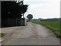
1
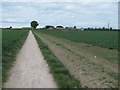
Track to Newlands Lane
This track (and footpath) leads from the track from Dumpton Lane towards Bromstone Road.
Image: © David Anstiss
Taken: 8 May 2011
0.09 miles
2
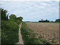
Footpath to Pyson's Road
This path leads from the track between Dumpton Lane and Bromstone Road.
In the background is Orchard House.
Image: © David Anstiss
Taken: 8 May 2011
0.09 miles
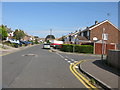
3
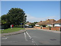
Shirley Avenue off West Dumpton Lane
West Dumpton Lane continues to the corner then it becomes Vine Close.
Image: © Nick Smith
Taken: 16 Sep 2011
0.10 miles
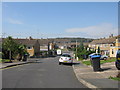
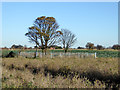
5
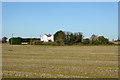
Orchard House, Broadstairs
Alone in fields which were orchards once, but not now. The wooded area to the right surrounds what was mapped some time ago as 'Old gasometer' - an extraordinary place to have one.
Image: © Robin Webster
Taken: 29 Nov 2016
0.17 miles
6
Bridleway and footpath junction near Dumpton
A bridleway track leads straight on from Dumpton Lane to Bromstone Road.
A footpath leads left towards Pysons Road.
Image: © David Anstiss
Taken: 8 May 2011
0.17 miles
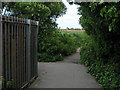
8
Path leading to Dumpton from Newlands Lane
Image: © Nick Smith
Taken: 16 Sep 2011
0.21 miles
9
Site of Little Newlands
It looks to have been some sort of yard most recently, but is disused, rubbishy and overgrown now. It is odd that it is so heavily fenced, and partly quite new at that.
Image: © Robin Webster
Taken: 29 Nov 2016
0.22 miles
10
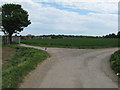
Track junction on Newlands Lane
A track leads from Pyson's Road, right to Newlands Farm and onwards to Newlands Road. Another track and footpath leads left towards another track between Dumpton Lane and Bromstone Road.
Image: © David Anstiss
Taken: 8 May 2011
0.23 miles