IMAGES TAKEN NEAR TO
Stonar Close, RAMSGATE, CT11 7BA
Introduction
This page details the photographs taken nearby to Stonar Close, CT11 7BA by members of the Geograph project.
The Geograph project started in 2005 with the aim of publishing, organising and preserving representative images for every square kilometre of Great Britain, Ireland and the Isle of Man.

There are currently over 7.5m images from over14,400 individuals and you can help contribute to the project by visiting https://www.geograph.org.uk
Image Map
Images are licensed for reuse under creativecommons.org/licenses/by-sa/2.0
Notes
- Clicking on the map will re-center to the selected point.
- The higher the marker number, the further away the image location is from the centre of the postcode.
Image Listing (22 Images Found)
Images are licensed for reuse under creativecommons.org/licenses/by-sa/2.0
Image
Details
Distance
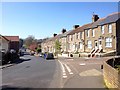
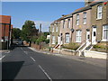
3
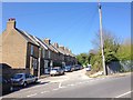
Dumpton Lane where it passes Newlands Primary School
Image: © Nick Smith
Taken: 16 Sep 2011
0.15 miles
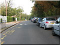
4
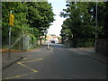
Narrowing of Dumpton Lane as it crosses the railway
Image: © Nick Smith
Taken: 16 Sep 2011
0.16 miles
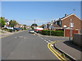
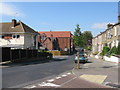
5
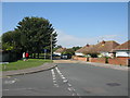
Shirley Avenue off West Dumpton Lane
West Dumpton Lane continues to the corner then it becomes Vine Close.
Image: © Nick Smith
Taken: 16 Sep 2011
0.17 miles
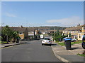
6
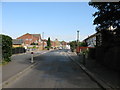
Dumpton Lane, looking north
From the section where it is reduced to single lane over the railway bridge.
Image: © Nick Smith
Taken: 16 Sep 2011
0.17 miles
9
College Road from junction with Dumpton Lane
Image: © Nick Smith
Taken: 16 Sep 2011
0.19 miles