IMAGES TAKEN NEAR TO
College Road, RAMSGATE, CT11 7AE
Introduction
This page details the photographs taken nearby to College Road, CT11 7AE by members of the Geograph project.
The Geograph project started in 2005 with the aim of publishing, organising and preserving representative images for every square kilometre of Great Britain, Ireland and the Isle of Man.

There are currently over 7.5m images from over14,400 individuals and you can help contribute to the project by visiting https://www.geograph.org.uk
Image Map
Images are licensed for reuse under creativecommons.org/licenses/by-sa/2.0
Notes
- Clicking on the map will re-center to the selected point.
- The higher the marker number, the further away the image location is from the centre of the postcode.
Image Listing (40 Images Found)
Images are licensed for reuse under creativecommons.org/licenses/by-sa/2.0
Image
Details
Distance
2
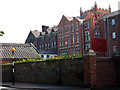
St Lawrence College on College Road
An independent, co-educational day and boarding school for ages 3-18 see http://www.slcuk.com
Image: © Nick Smith
Taken: 16 Sep 2011
0.03 miles

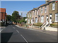
5
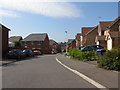
St Christopher's Mews
A small modern estate off College Road.
Image: © Nick Smith
Taken: 16 Sep 2011
0.13 miles
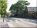
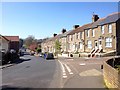
6
College Road from junction with Dumpton Lane
Image: © Nick Smith
Taken: 16 Sep 2011
0.14 miles
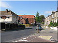
9
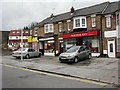
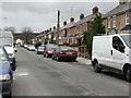
Shops at the northern end of St Luke's Avenue
Image: © Nick Smith
Taken: 31 Dec 2009
0.16 miles