IMAGES TAKEN NEAR TO
Grummock Avenue, RAMSGATE, CT11 0RR
Introduction
This page details the photographs taken nearby to Grummock Avenue, CT11 0RR by members of the Geograph project.
The Geograph project started in 2005 with the aim of publishing, organising and preserving representative images for every square kilometre of Great Britain, Ireland and the Isle of Man.

There are currently over 7.5m images from over14,400 individuals and you can help contribute to the project by visiting https://www.geograph.org.uk
Image Map
Images are licensed for reuse under creativecommons.org/licenses/by-sa/2.0
Notes
- Clicking on the map will re-center to the selected point.
- The higher the marker number, the further away the image location is from the centre of the postcode.
Image Listing (31 Images Found)
Images are licensed for reuse under creativecommons.org/licenses/by-sa/2.0
Image
Details
Distance
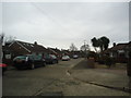
2
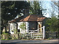
South Lodge, Nethercourt Park
On Nethercourt Hill. Beside a lane into the park (campsite).
Image: © David Anstiss
Taken: 10 Apr 2011
0.10 miles
4
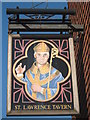
St.Lawrence Tavern, Pub Sign, Ramsgate
As seen on Image
Image: © David Anstiss
Taken: 10 Apr 2011
0.14 miles

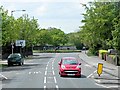
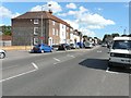
6
St. Lawrence Tavern, Ramsgate
On the junction of the A253 Ramsgate High Street (on the right) and Ashburnham Road (in front).
Image: © David Anstiss
Taken: 10 Apr 2011
0.15 miles
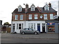
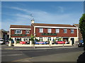
8
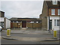
St. Lawrence Parish Hall, Ramsgate
On the A253 High Street.
Image: © David Anstiss
Taken: 6 Feb 2011
0.18 miles