IMAGES TAKEN NEAR TO
Drybeck Avenue, RAMSGATE, CT11 0NX
Introduction
This page details the photographs taken nearby to Drybeck Avenue, CT11 0NX by members of the Geograph project.
The Geograph project started in 2005 with the aim of publishing, organising and preserving representative images for every square kilometre of Great Britain, Ireland and the Isle of Man.

There are currently over 7.5m images from over14,400 individuals and you can help contribute to the project by visiting https://www.geograph.org.uk
Image Map
Images are licensed for reuse under creativecommons.org/licenses/by-sa/2.0
Notes
- Clicking on the map will re-center to the selected point.
- The higher the marker number, the further away the image location is from the centre of the postcode.
Image Listing (9 Images Found)
Images are licensed for reuse under creativecommons.org/licenses/by-sa/2.0
Image
Details
Distance
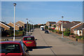
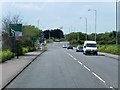
2
Windermere Avenue by Canterbury Road East
These are the first houses coming into the Ramsgate area.
Image: © David Howard
Taken: 31 Jul 2016
0.07 miles
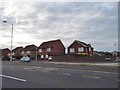
6
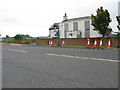
No longer Lord of the Manor
The property appears to be called The Lord of the Manor, the name is given to the immediate area also. It might be the new road development which has caused the demise of this house (see various submissions regarding East Kent Access phase 2).
Image: © Nick Smith
Taken: 4 Sep 2011
0.21 miles
7
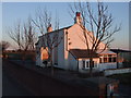
Empty house by the Lord of the Manor roundabout, near Ramsgate
Image: © Chris Whippet
Taken: 7 Mar 2010
0.21 miles
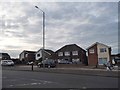
8
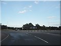
Roundabout on Canterbury Road, Ramsgate
Image: © David Howard
Taken: 31 Jul 2016
0.24 miles
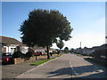
9
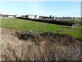
Looking northeast from Sandwich Road
Towards the back of the Lord of the Manor, which is a derelict property situated beside Canterbury Road East.
Image: © John Baker
Taken: 16 Feb 2016
0.25 miles