IMAGES TAKEN NEAR TO
Pegwell, RAMSGATE, CT11 0NH
Introduction
This page details the photographs taken nearby to CT11 0NH by members of the Geograph project.
The Geograph project started in 2005 with the aim of publishing, organising and preserving representative images for every square kilometre of Great Britain, Ireland and the Isle of Man.

There are currently over 7.5m images from over14,400 individuals and you can help contribute to the project by visiting https://www.geograph.org.uk
Image Map
Images are licensed for reuse under creativecommons.org/licenses/by-sa/2.0
Notes
- Clicking on the map will re-center to the selected point.
- The higher the marker number, the further away the image location is from the centre of the postcode.
Image Listing (91 Images Found)
Images are licensed for reuse under creativecommons.org/licenses/by-sa/2.0
Image
Details
Distance
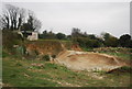
3
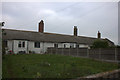
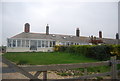
Coastguard Cottages, Pegwell Bay
Most of these are now holiday lets.
Image: © Robert Eva
Taken: 5 Jan 2019
0.01 miles
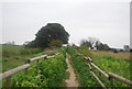
8
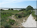
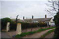
Footpath near Coastguard Cottages
This path (part of the Viking Coastal Trail and Thanet Coastal Path) leads from Ramsgate towards Cliffs End, around Pegwell Bay.
Image: © David Anstiss
Taken: 23 May 2011
0.06 miles
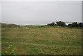
9
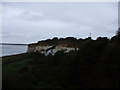
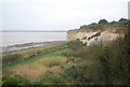
Pegwell Bay cliffs
Taken from over the wall seen on the left of this picture Image
Image: © Phillip Perry
Taken: 23 Sep 2008
0.07 miles