IMAGES TAKEN NEAR TO
Mark Avenue, RAMSGATE, CT11 0JS
Introduction
This page details the photographs taken nearby to Mark Avenue, CT11 0JS by members of the Geograph project.
The Geograph project started in 2005 with the aim of publishing, organising and preserving representative images for every square kilometre of Great Britain, Ireland and the Isle of Man.

There are currently over 7.5m images from over14,400 individuals and you can help contribute to the project by visiting https://www.geograph.org.uk
Image Map
Images are licensed for reuse under creativecommons.org/licenses/by-sa/2.0
Notes
- Clicking on the map will re-center to the selected point.
- The higher the marker number, the further away the image location is from the centre of the postcode.
Image Listing (92 Images Found)
Images are licensed for reuse under creativecommons.org/licenses/by-sa/2.0
Image
Details
Distance
1
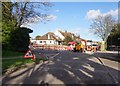
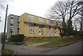
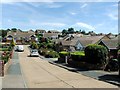
Goodwin Road, Ramsgate
The coast path has a short section in the suburbs of Ramsgate before getting back to the seaside.
Image: © Des Blenkinsopp
Taken: 15 Jun 2021
0.11 miles
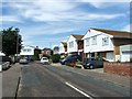
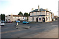
6
The Chilton Tavern, Ramsgate
On the junction of Pegwell Road (on the right) and Downs Road (on the left).
Image: © David Anstiss
Taken: 10 Apr 2011
0.13 miles
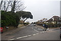
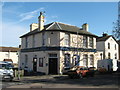
9
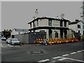
Chilton Tavern, Pegwell Road
The pub, which had been derelict for some time, was badly damaged by fire on 8 October 2022.
David Anstiss’ view of Image shows the building, when it was open for business.
Image: © John Baker
Taken: 4 Dec 2022
0.14 miles