IMAGES TAKEN NEAR TO
Warre Avenue, RAMSGATE, CT11 0HD
Introduction
This page details the photographs taken nearby to Warre Avenue, CT11 0HD by members of the Geograph project.
The Geograph project started in 2005 with the aim of publishing, organising and preserving representative images for every square kilometre of Great Britain, Ireland and the Isle of Man.

There are currently over 7.5m images from over14,400 individuals and you can help contribute to the project by visiting https://www.geograph.org.uk
Image Map
Images are licensed for reuse under creativecommons.org/licenses/by-sa/2.0
Notes
- Clicking on the map will re-center to the selected point.
- The higher the marker number, the further away the image location is from the centre of the postcode.
Image Listing (155 Images Found)
Images are licensed for reuse under creativecommons.org/licenses/by-sa/2.0
Image
Details
Distance
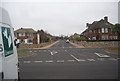
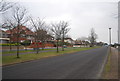
6
Installation of gas pipes
View shows a trench has been dug on the corner of Stancomb Avenue and Royal Esplanade.
Image: © John Baker
Taken: 18 Apr 2021
0.09 miles
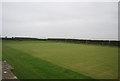
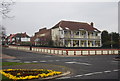
9
Ramsgate Croquet Club
On West Cliff, next to Ramsgate Esplanade Bowls Club.
Image: © Christine Johnstone
Taken: 16 Feb 2022
0.11 miles