IMAGES TAKEN NEAR TO
Watchester Avenue, RAMSGATE, CT11 0EU
Introduction
This page details the photographs taken nearby to Watchester Avenue, CT11 0EU by members of the Geograph project.
The Geograph project started in 2005 with the aim of publishing, organising and preserving representative images for every square kilometre of Great Britain, Ireland and the Isle of Man.

There are currently over 7.5m images from over14,400 individuals and you can help contribute to the project by visiting https://www.geograph.org.uk
Image Map
Images are licensed for reuse under creativecommons.org/licenses/by-sa/2.0
Notes
- Clicking on the map will re-center to the selected point.
- The higher the marker number, the further away the image location is from the centre of the postcode.
Image Listing (172 Images Found)
Images are licensed for reuse under creativecommons.org/licenses/by-sa/2.0
Image
Details
Distance
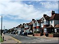
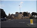
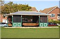
6
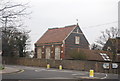
St Augustine's Abbey
Grade II listed. http://www.britishlistedbuildings.co.uk/en-172006-st-augustine-s-abbey-with-perimeter-wall
Image: © N Chadwick
Taken: 5 Apr 2012
0.08 miles
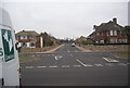
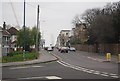
7
Royal Parade at the junction of St Augustine's Road
Image: © David Howard
Taken: 31 Jul 2016
0.08 miles
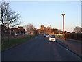
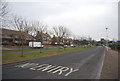
9
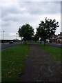
Royal Esplanade, Ramsgate
A footpath that runs through the middle of this 'dual-carriageway'.
Image: © Phillip Perry
Taken: 23 Sep 2008
0.08 miles