IMAGES TAKEN NEAR TO
Edith Road, RAMSGATE, CT11 0EN
Introduction
This page details the photographs taken nearby to Edith Road, CT11 0EN by members of the Geograph project.
The Geograph project started in 2005 with the aim of publishing, organising and preserving representative images for every square kilometre of Great Britain, Ireland and the Isle of Man.

There are currently over 7.5m images from over14,400 individuals and you can help contribute to the project by visiting https://www.geograph.org.uk
Image Map
Images are licensed for reuse under creativecommons.org/licenses/by-sa/2.0
Notes
- Clicking on the map will re-center to the selected point.
- The higher the marker number, the further away the image location is from the centre of the postcode.
Image Listing (76 Images Found)
Images are licensed for reuse under creativecommons.org/licenses/by-sa/2.0
Image
Details
Distance
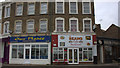
4
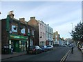
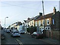
Takeaway Cafes on Grange Road, Ramsgate
On the junction of Grange Road (in front) and Ashburnham Road (on the right).
Image: © David Anstiss
Taken: 6 Feb 2011
0.06 miles
6
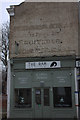
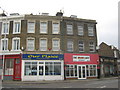
The Ram coffee house, Grange Road
Complete with a ghost sign above it.
Image: © Robert Eva
Taken: 5 Jan 2019
0.06 miles
10
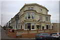
Hotel De Ville, Willson's Road, Ramsgate
Image: © Robert Eva
Taken: 5 Jan 2019
0.07 miles