IMAGES TAKEN NEAR TO
Chapel Road, RAMSGATE, CT11 0BS
Introduction
This page details the photographs taken nearby to Chapel Road, CT11 0BS by members of the Geograph project.
The Geograph project started in 2005 with the aim of publishing, organising and preserving representative images for every square kilometre of Great Britain, Ireland and the Isle of Man.

There are currently over 7.5m images from over14,400 individuals and you can help contribute to the project by visiting https://www.geograph.org.uk
Image Map
Images are licensed for reuse under creativecommons.org/licenses/by-sa/2.0
Notes
- Clicking on the map will re-center to the selected point.
- The higher the marker number, the further away the image location is from the centre of the postcode.
Image Listing (74 Images Found)
Images are licensed for reuse under creativecommons.org/licenses/by-sa/2.0
Image
Details
Distance
1
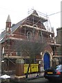
Chapel undergoing renovation
This small chapel on Chapel Road is undergoing renovation works, presumably to convert it into a private house.
Image: © David Anstiss
Taken: 6 Feb 2011
0.04 miles
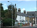

6
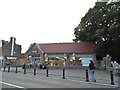
Tesco Express on High Street St Lawrence
Named after the church next door on the right
Image: © David Howard
Taken: 31 Jul 2016
0.07 miles
7

St Laurence-in-Thanet Church from High Street
Image: © David Howard
Taken: 31 Jul 2016
0.07 miles
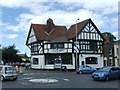
8
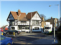
The Wheatsheaf, Ramsgate
Missing its inn sign, but possibly still open.
Image: © Robin Webster
Taken: 29 Nov 2016
0.07 miles