IMAGES TAKEN NEAR TO
Newmans Close, BROADSTAIRS, CT10 3PL
Introduction
This page details the photographs taken nearby to Newmans Close, CT10 3PL by members of the Geograph project.
The Geograph project started in 2005 with the aim of publishing, organising and preserving representative images for every square kilometre of Great Britain, Ireland and the Isle of Man.

There are currently over 7.5m images from over14,400 individuals and you can help contribute to the project by visiting https://www.geograph.org.uk
Image Map
Images are licensed for reuse under creativecommons.org/licenses/by-sa/2.0
Notes
- Clicking on the map will re-center to the selected point.
- The higher the marker number, the further away the image location is from the centre of the postcode.
Image Listing (18 Images Found)
Images are licensed for reuse under creativecommons.org/licenses/by-sa/2.0
Image
Details
Distance
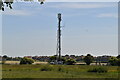
6
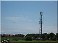
Mobile Phone Mast
Seen from Callis Court Road.
In the corner of a field of Elmwood Farm.
In the background is Broadhall Manor.
Image: © David Anstiss
Taken: 8 May 2011
0.19 miles
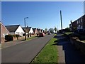
8
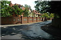
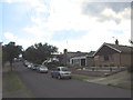
Houses in St Peter's
Houses off Callis Court Road in St Peter's.
Image: © Philip Halling
Taken: 19 Jul 2009
0.20 miles
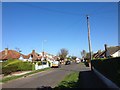
9
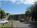
Maurice House
This large building on Callis Court Road is used by the British Legion as a care home.
See http://www.housingcare.org/housing-care/facility-info-146471-maurice-house-broadstairs-england.aspx
Image: © David Anstiss
Taken: 8 May 2011
0.21 miles