IMAGES TAKEN NEAR TO
Northdown Trading Estate, Dane Valley Road, BROADSTAIRS, CT10 3JL
Introduction
This page details the photographs taken nearby to Northdown Trading Estate, Dane Valley Road, CT10 3JL by members of the Geograph project.
The Geograph project started in 2005 with the aim of publishing, organising and preserving representative images for every square kilometre of Great Britain, Ireland and the Isle of Man.

There are currently over 7.5m images from over14,400 individuals and you can help contribute to the project by visiting https://www.geograph.org.uk
Image Map
Images are licensed for reuse under creativecommons.org/licenses/by-sa/2.0
Notes
- Clicking on the map will re-center to the selected point.
- The higher the marker number, the further away the image location is from the centre of the postcode.
Image Listing (9 Images Found)
Images are licensed for reuse under creativecommons.org/licenses/by-sa/2.0
Image
Details
Distance
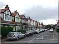
1
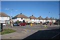
Westover Road
Semi detached houses, looking from junction of Dane Valley Road onto Northdown Road, and Northdown Road onto Westeover Road..
Image: © Oast House Archive
Taken: 21 Sep 2010
0.04 miles
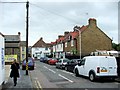
2
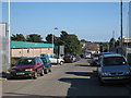
Dane Valley Road
Industrial estate road.
Image: © Oast House Archive
Taken: 21 Sep 2010
0.13 miles
3
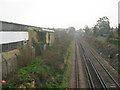
Railway to Broadstairs
As seen from a footbridge beside Northdown Road.
This line leads from Margate towards Broadstairs.
Northdown Industrial Park is on the left.
Image: © David Anstiss
Taken: 20 Feb 2011
0.13 miles
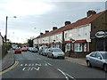
4
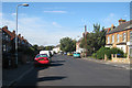
Northdown Road
A road of semi detached and detached house leading between Church Street and Westover Road.
Image: © Oast House Archive
Taken: 21 Sep 2010
0.20 miles
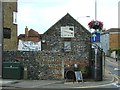
9
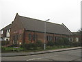
Westover Free Church
On the junction of Prince Charles Avenue (on the left) and Linley Road (on the right).
Image: © David Anstiss
Taken: 20 Feb 2011
0.25 miles