IMAGES TAKEN NEAR TO
Ocean Drive, BROADSTAIRS, CT10 3BX
Introduction
This page details the photographs taken nearby to Ocean Drive, CT10 3BX by members of the Geograph project.
The Geograph project started in 2005 with the aim of publishing, organising and preserving representative images for every square kilometre of Great Britain, Ireland and the Isle of Man.

There are currently over 7.5m images from over14,400 individuals and you can help contribute to the project by visiting https://www.geograph.org.uk
Image Map
Images are licensed for reuse under creativecommons.org/licenses/by-sa/2.0
Notes
- Clicking on the map will re-center to the selected point.
- The higher the marker number, the further away the image location is from the centre of the postcode.
Image Listing (44 Images Found)
Images are licensed for reuse under creativecommons.org/licenses/by-sa/2.0
Image
Details
Distance
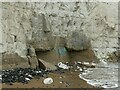
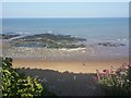
1
Cliff at north end of Stone Bay
Some concrete anti-erosion measures have been taken here, but have partly been eroded themselves. Most are now stood off the cliff a little, with water channelling behind probably increasing the erosion. The concern here is a few otherwise desirable properties on top of the cliff.
Image: © Robin Webster
Taken: 23 Nov 2011
0.04 miles
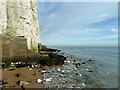
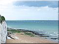
2
Cliffs towards Hope Point
Underpinned to reduce erosion, as there are residential properties on top. Classic chalk cliffs with bands of flint, which when washed out of the cliff tend to settle on the beach as can be seen to the left of the picture.
Image: © Alan Murray-Rust
Taken: 2 Sep 2022
0.06 miles
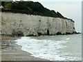
4
Chalk cliff with late Holocene conglomerate intrusion
Can otherwise be described as 20th century (late Holocene) concrete (definitely a conglomerate!) underpinning of the cliff to limit erosion.
Image: © Alan Murray-Rust
Taken: 2 Sep 2022
0.07 miles
7
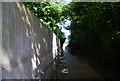
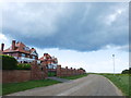
Thanet Coastal Path descending to Stone Bay
Image: © N Chadwick
Taken: 4 Jul 2009
0.10 miles
9
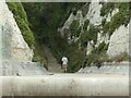
Stone Gap at the north end of Stone Bay
The only gulley in this stretch of the chalk cliffs provides a route for the Thanet Coastal Path.
Image: © Alan Murray-Rust
Taken: 2 Sep 2022
0.11 miles