IMAGES TAKEN NEAR TO
Dane Court Gardens, BROADSTAIRS, CT10 2SB
Introduction
This page details the photographs taken nearby to Dane Court Gardens, CT10 2SB by members of the Geograph project.
The Geograph project started in 2005 with the aim of publishing, organising and preserving representative images for every square kilometre of Great Britain, Ireland and the Isle of Man.

There are currently over 7.5m images from over14,400 individuals and you can help contribute to the project by visiting https://www.geograph.org.uk
Image Map
Images are licensed for reuse under creativecommons.org/licenses/by-sa/2.0
Notes
- Clicking on the map will re-center to the selected point.
- The higher the marker number, the further away the image location is from the centre of the postcode.
Image Listing (32 Images Found)
Images are licensed for reuse under creativecommons.org/licenses/by-sa/2.0
Image
Details
Distance
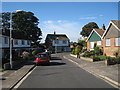
3
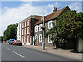
Broadstairs: Dane Court Gardens, St Peter's
Bungalow estate in the St Peter's area of Broadstairs with the tower of the eponymous church visible over the trees in the background.
Image: © Nigel Cox
Taken: 7 Jun 2007
0.09 miles
4
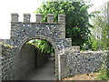
Archway in St.Peter's Church Cemetery
This archway is on St.Peter's footpath leading from Vicarage Street towards College Road, Margate.
It is also used by the Turner and Dickens Walk leading between Broadstairs and Margate.
Image: © David Anstiss
Taken: 8 May 2011
0.10 miles
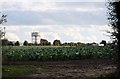
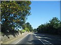
7
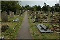
St Peter's churchyard
St Peter's church stands in a very large churchyard much of which is within the grid square immediately to the west, as pictured here.
Image: © Philip Halling
Taken: 19 Jul 2009
0.14 miles
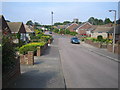
8
Canterbury Close
Short U-shaped cul-de-sac of detached houses and bunaglows.
Image: © Oast House Archive
Taken: 21 Sep 2010
0.14 miles
9
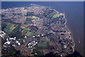
North east kent from the air
The north end of Ramsgate is just visible at the bottom of the photo. St Peters is in the centre, with Broadstairs, Kingsgate and Margate visible around the coast. Viewed from a Brussels bound flight from Prestwick.
Image: © Thomas Nugent
Taken: 1 Mar 2010
0.17 miles