IMAGES TAKEN NEAR TO
Margate Road, BROADSTAIRS, CT10 2PR
Introduction
This page details the photographs taken nearby to Margate Road, CT10 2PR by members of the Geograph project.
The Geograph project started in 2005 with the aim of publishing, organising and preserving representative images for every square kilometre of Great Britain, Ireland and the Isle of Man.

There are currently over 7.5m images from over14,400 individuals and you can help contribute to the project by visiting https://www.geograph.org.uk
Image Map
Images are licensed for reuse under creativecommons.org/licenses/by-sa/2.0
Notes
- Clicking on the map will re-center to the selected point.
- The higher the marker number, the further away the image location is from the centre of the postcode.
Image Listing (32 Images Found)
Images are licensed for reuse under creativecommons.org/licenses/by-sa/2.0
Image
Details
Distance
1

Halfords Autocentre, Ramsgate Road (A254)
Situated just beyond the Halfords store, seen in Image As the banner indicates, it is opening soon.
Image: © John Baker
Taken: 27 Oct 2014
0.00 miles
2
Looking north along Ramsgate Road (A254)
Immediately on the right is a side wall of a Halfords store, which is situated on the Westwood Cross Shopping Centre site.
Image: © John Baker
Taken: 27 Oct 2014
0.03 miles
3

Yet more construction work...
What looks like yet another retail unit of some description being constructed in the vicinity of the Westwood Cross Shopping Centre, this time on Margate Road opposite the Homebase and Argos complex, which was completed 2 years ago. I shall keep you updated of what it is as soon as it is complete! View taken from Haine Road looking northeast in the direction of St Peters.
UPDATE September 2009: I've been informed that this is a new Dunelm Mill store.
Image: © Robert Lamb
Taken: 15 Feb 2009
0.03 miles
4

New superstore
This is the rear of a new curtains superstore!
Image: © Jonathan Billinger
Taken: 25 Apr 2007
0.06 miles


7
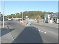
Roadworks beside Ramsgate Road (A254)
On 7 July 2014, it was reported in the Isle of Thanet Gazette that work had begun on a £4.8 million road scheme to reduce traffic congestion at Westwood Cross. Engineers and road workers from Jackson Civil Engineering Ltd were to widen Poorhole Lane, construct a shared footway for pedestrians and cyclists and to build roundabout junctions at either end of the road. This will allow some traffic to bypass the A256/A254 Westwood roundabout.http://www.thanetgazette.co.uk/Congestion-Busting-Road-Scheme/story-21338541-detail/story.html On the day of this view, Poorhole Lane was closed to traffic.
Image: © John Baker
Taken: 27 Oct 2014
0.08 miles

10

Dunelm Mill store at Westwood Retail Park
Image: © PAUL FARMER
Taken: 5 Sep 2009
0.10 miles