IMAGES TAKEN NEAR TO
Westwood Road, BROADSTAIRS, CT10 2NR
Introduction
This page details the photographs taken nearby to Westwood Road, CT10 2NR by members of the Geograph project.
The Geograph project started in 2005 with the aim of publishing, organising and preserving representative images for every square kilometre of Great Britain, Ireland and the Isle of Man.

There are currently over 7.5m images from over14,400 individuals and you can help contribute to the project by visiting https://www.geograph.org.uk
Image Map
Images are licensed for reuse under creativecommons.org/licenses/by-sa/2.0
Notes
- Clicking on the map will re-center to the selected point.
- The higher the marker number, the further away the image location is from the centre of the postcode.
Image Listing (15 Images Found)
Images are licensed for reuse under creativecommons.org/licenses/by-sa/2.0
Image
Details
Distance
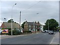
2

Loknstore Depot, Poorhole Lane
One of the many warehouse style business premises in this edge of town area.
Image: © Des Blenkinsopp
Taken: 11 Aug 2017
0.09 miles
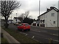
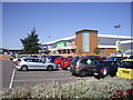
3

Tesco Extra, Thanet
One of two supermarkets opposite each other, but 5 minutes walk away, close to Broadstairs.
Image: © Phillip Perry
Taken: 31 Oct 2008
0.11 miles
4
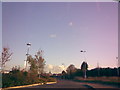
New access road to Currys and PC World Car Park
This is the new access road (constructed in 2007) to the new Currys and PC World stores at Westwood. It is lit with some quite contemporary-looking streetlights called DW Windsor Rios, which parade neatly down one side of the road. View taken looking northwest towards Ramsgate.
Image: © Robert Lamb
Taken: 27 Oct 2008
0.11 miles

7
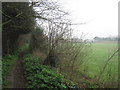
Footpath to Westwood Road
This path followed a field edge path from Dane Court Road, past Buddles Farm, then it passes between two large playing fields of St.George's Schooll.
Image: © David Anstiss
Taken: 20 Feb 2011
0.16 miles
8
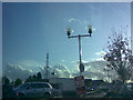
Ornate spherical lamp posts in Matalan car park
The car park to the Matalan store in Westwood is lit with these ornate spherical lamp posts - you can see a little webbing under each bracket with wrought iron decorations on them. View taken looking south towards Westwood Road.
Image: © Robert Lamb
Taken: 27 Oct 2008
0.19 miles
9
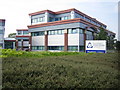
Canterbury Christ Church University
This is the Broadstairs Campus of the University, which was originally founded as a teacher training college in 1962. It now has a total of about 14,000 students on this and three other sites. This site is on Northwood Road in Broadstairs. The Campus website is here http://www.canterbury.ac.uk/broadstairs/ Rather bizarrely, on the "How to find us" page, it claims that "the road connects with London's orbital M25" as if to suggest that there are some roads in the country that don't!
Image: © Nigel Cox
Taken: 7 Jun 2007
0.21 miles
10
Dunelm Mill store at Westwood Retail Park
Image: © PAUL FARMER
Taken: 5 Sep 2009
0.21 miles