IMAGES TAKEN NEAR TO
Patricia Way, BROADSTAIRS, CT10 2LE
Introduction
This page details the photographs taken nearby to Patricia Way, CT10 2LE by members of the Geograph project.
The Geograph project started in 2005 with the aim of publishing, organising and preserving representative images for every square kilometre of Great Britain, Ireland and the Isle of Man.

There are currently over 7.5m images from over14,400 individuals and you can help contribute to the project by visiting https://www.geograph.org.uk
Image Map
Images are licensed for reuse under creativecommons.org/licenses/by-sa/2.0
Notes
- Clicking on the map will re-center to the selected point.
- The higher the marker number, the further away the image location is from the centre of the postcode.
Image Listing (7 Images Found)
Images are licensed for reuse under creativecommons.org/licenses/by-sa/2.0
Image
Details
Distance
1
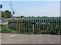
Cabbage fields of Thanet from Newlands Lane
Image: © Nick Smith
Taken: 16 Sep 2011
0.19 miles
2
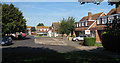
The Hawthorns
An estate of 'chalet style' bungalows. Despite the hideous flat roof dormer windows looking like later additions, all the houses have been built in this style.
Image: © Oast House Archive
Taken: 21 Sep 2010
0.19 miles
3
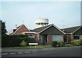
Water tower over bungalows
The water tower on Rumfields Road dominates the modern housing estates to the west of it.
Image: © Thomas Grant
Taken: 7 Jun 2007
0.24 miles
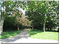
5
Junction of Hope's Lane off Pyson's Road
Image: © Nick Smith
Taken: 16 Sep 2011
0.24 miles
6
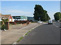
View along Pyson's Road
The recently closed Focus DIY store is on the right.
Image: © Nick Smith
Taken: 16 Sep 2011
0.25 miles
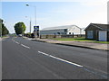
7

Focus DIY Superstore, Northwood
On Pyson's Road.
In the news currently, under administration for default of a credit. See http://www.bbc.co.uk/news/business-13283501
Image: © David Anstiss
Taken: 8 May 2011
0.25 miles