IMAGES TAKEN NEAR TO
Park Avenue, BROADSTAIRS, CT10 2EY
Introduction
This page details the photographs taken nearby to Park Avenue, CT10 2EY by members of the Geograph project.
The Geograph project started in 2005 with the aim of publishing, organising and preserving representative images for every square kilometre of Great Britain, Ireland and the Isle of Man.

There are currently over 7.5m images from over14,400 individuals and you can help contribute to the project by visiting https://www.geograph.org.uk
Image Map
Images are licensed for reuse under creativecommons.org/licenses/by-sa/2.0
Notes
- Clicking on the map will re-center to the selected point.
- The higher the marker number, the further away the image location is from the centre of the postcode.
Image Listing (9 Images Found)
Images are licensed for reuse under creativecommons.org/licenses/by-sa/2.0
Image
Details
Distance
2
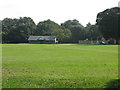
Playing fields on Park Avenue, home of Broadstairs Cricket Club
Image: © Nick Smith
Taken: 16 Sep 2011
0.13 miles
3
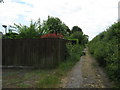
Bridleway to Dumpton
A track leads from Bromstone Road, via a track to Dumpton Lane.
It also leads to garages behind Wellesley Close and Marshborough Close.
Image: © David Anstiss
Taken: 8 May 2011
0.16 miles
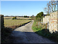
4
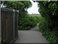
Bridleway and footpath junction near Dumpton
A bridleway track leads straight on from Dumpton Lane to Bromstone Road.
A footpath leads left towards Pysons Road.
Image: © David Anstiss
Taken: 8 May 2011
0.18 miles
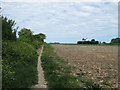
5
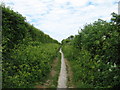
Track to Orchard House
A dog-leg route around field margins.
Image: © Robin Webster
Taken: 29 Nov 2016
0.21 miles
7
Footpath to Pyson's Road
This path leads from the track between Dumpton Lane and Bromstone Road.
In the background is Orchard House.
Image: © David Anstiss
Taken: 8 May 2011
0.23 miles

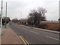
9
Boat on a roundabout
Tatty old boat used as a flowerbed. Junction of Ramsgate and Bromstone Roads.
Image: © Thomas Grant
Taken: 7 Jun 2007
0.24 miles