IMAGES TAKEN NEAR TO
Darren Gardens, BROADSTAIRS, CT10 2EF
Introduction
This page details the photographs taken nearby to Darren Gardens, CT10 2EF by members of the Geograph project.
The Geograph project started in 2005 with the aim of publishing, organising and preserving representative images for every square kilometre of Great Britain, Ireland and the Isle of Man.

There are currently over 7.5m images from over14,400 individuals and you can help contribute to the project by visiting https://www.geograph.org.uk
Image Map
Images are licensed for reuse under creativecommons.org/licenses/by-sa/2.0
Notes
- Clicking on the map will re-center to the selected point.
- The higher the marker number, the further away the image location is from the centre of the postcode.
Image Listing (32 Images Found)
Images are licensed for reuse under creativecommons.org/licenses/by-sa/2.0
Image
Details
Distance
2
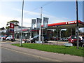
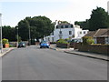
Garage and filling station on the Ramsgate Road
Image: © Nick Smith
Taken: 16 Sep 2011
0.08 miles
4
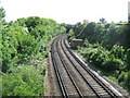
Railway to Dumpton Park
As seen from Image
This line leads from Margate (via Broadstairs) towards Dumpton Park and then onwards to Ramsgate and the line to London.
In the background is Salisbury Avenue road bridge.
Image: © David Anstiss
Taken: 8 May 2011
0.11 miles
10
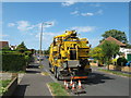
Recycling Unit on Salisbury Drive
This large yellow machine is removing waste liquids from the drains!
GULP!
Image: © David Anstiss
Taken: 8 May 2011
0.13 miles