IMAGES TAKEN NEAR TO
North Foreland Road, BROADSTAIRS, CT10 1FE
Introduction
This page details the photographs taken nearby to North Foreland Road, CT10 1FE by members of the Geograph project.
The Geograph project started in 2005 with the aim of publishing, organising and preserving representative images for every square kilometre of Great Britain, Ireland and the Isle of Man.

There are currently over 7.5m images from over14,400 individuals and you can help contribute to the project by visiting https://www.geograph.org.uk
Image Map
Images are licensed for reuse under creativecommons.org/licenses/by-sa/2.0
Notes
- Clicking on the map will re-center to the selected point.
- The higher the marker number, the further away the image location is from the centre of the postcode.
Image Listing (42 Images Found)
Images are licensed for reuse under creativecommons.org/licenses/by-sa/2.0
Image
Details
Distance
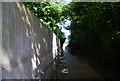
4
Thanet Coastal Path descending to Stone Bay
Image: © N Chadwick
Taken: 4 Jul 2009
0.08 miles
7
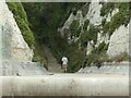
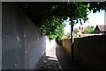
Stone Gap at the north end of Stone Bay
The only gulley in this stretch of the chalk cliffs provides a route for the Thanet Coastal Path.
Image: © Alan Murray-Rust
Taken: 2 Sep 2022
0.10 miles
9
Thanet Coastal Path descending to Stone Bay
Image: © N Chadwick
Taken: 4 Jul 2009
0.10 miles
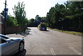
10
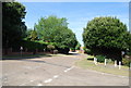
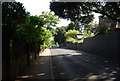
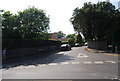
Junction of North Foreland Avenue & Cliff Rd
Image: © N Chadwick
Taken: 4 Jul 2009
0.11 miles