IMAGES TAKEN NEAR TO
Lindenthorpe Road, BROADSTAIRS, CT10 1BG
Introduction
This page details the photographs taken nearby to Lindenthorpe Road, CT10 1BG by members of the Geograph project.
The Geograph project started in 2005 with the aim of publishing, organising and preserving representative images for every square kilometre of Great Britain, Ireland and the Isle of Man.

There are currently over 7.5m images from over14,400 individuals and you can help contribute to the project by visiting https://www.geograph.org.uk
Image Map
Images are licensed for reuse under creativecommons.org/licenses/by-sa/2.0
Notes
- Clicking on the map will re-center to the selected point.
- The higher the marker number, the further away the image location is from the centre of the postcode.
Image Listing (47 Images Found)
Images are licensed for reuse under creativecommons.org/licenses/by-sa/2.0
Image
Details
Distance
7
Welcome to Thanet Wanderers and Broadstairs & St Peter's Tennis Club
Image: © N Chadwick
Taken: 15 Jun 2022
0.12 miles
8
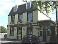
The Lanthorne Public House, Broadstairs
On the junction of Callis Court Road (in front) and Stanley Road (on the left).
Image: © David Anstiss
Taken: 8 May 2011
0.12 miles
9
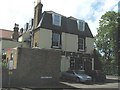
The Lanthorne, Broadstairs (2)
On the junction of Callis Court Road (in background) and Stanley Road (in front).
Image: © David Anstiss
Taken: 8 May 2011
0.12 miles