IMAGES TAKEN NEAR TO
Bradstow Way, BROADSTAIRS, CT10 1AR
Introduction
This page details the photographs taken nearby to Bradstow Way, CT10 1AR by members of the Geograph project.
The Geograph project started in 2005 with the aim of publishing, organising and preserving representative images for every square kilometre of Great Britain, Ireland and the Isle of Man.

There are currently over 7.5m images from over14,400 individuals and you can help contribute to the project by visiting https://www.geograph.org.uk
Image Map
Images are licensed for reuse under creativecommons.org/licenses/by-sa/2.0
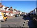
Notes
- Clicking on the map will re-center to the selected point.
- The higher the marker number, the further away the image location is from the centre of the postcode.
Image Listing (97 Images Found)
Images are licensed for reuse under creativecommons.org/licenses/by-sa/2.0
Image
Details
Distance
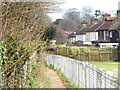
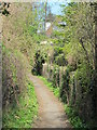
2
Footpath in between the railway and Masons Rise, CT10
Image: © Mike Quinn
Taken: 23 Apr 2013
0.09 miles
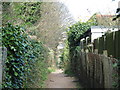
8
St. Peter's Park Road / Ethel Road, CT10
Image: © Mike Quinn
Taken: 23 Apr 2013
0.13 miles
9
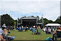
The Stage, Broadstairs Folk Week
The stage and arena for the folk week in Broadstairs this year is sited in the Memorial Recreation Ground.
Image: © Trevor Harris
Taken: 12 Aug 2021
0.14 miles
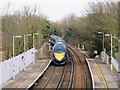
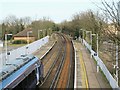
10
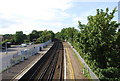
Looking north along the tracks, Broadstairs Station
Image: © N Chadwick
Taken: 4 Jul 2009
0.14 miles