IMAGES TAKEN NEAR TO
Crowborough Close, WARLINGHAM, CR6 9SP
Introduction
This page details the photographs taken nearby to Crowborough Close, CR6 9SP by members of the Geograph project.
The Geograph project started in 2005 with the aim of publishing, organising and preserving representative images for every square kilometre of Great Britain, Ireland and the Isle of Man.

There are currently over 7.5m images from over14,400 individuals and you can help contribute to the project by visiting https://www.geograph.org.uk
Image Map
Images are licensed for reuse under creativecommons.org/licenses/by-sa/2.0
Notes
- Clicking on the map will re-center to the selected point.
- The higher the marker number, the further away the image location is from the centre of the postcode.
Image Listing (28 Images Found)
Images are licensed for reuse under creativecommons.org/licenses/by-sa/2.0
Image
Details
Distance
1
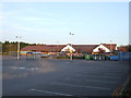
Sainsbury's, Warlingham
Sainsbury's supermarket in Warlingham, Surrey.
The supermarket is built on the site of a bus garage which closed in 1990. A photo of the bus garage is here: Image
The car park is empty, indicating that the supermarket had closed for the day when this photo was taken.
Image: © Malc McDonald
Taken: 23 Oct 2011
0.09 miles
2
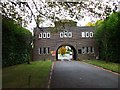
Greenlawn Memorial Park, Warlingham
The main entrance
Image: © Phillip Perry
Taken: 17 Oct 2009
0.10 miles
3

Sainsbury's, Warlingham
Another view of Image A reminder of the Chelsham bus garage which stood here is that the 403 service terminates here.
Image: © Derek Harper
Taken: 9 Dec 2011
0.12 miles
4

Coal tax post, Warlingham
Described at http://www.exploringsurreyspast.org.uk/getRecord?identifier=SHHER_11152 . It stands beside Image, and was relocated here in July 1994; previously it was at the corner of Limpsfield Road and Chelsham Road,http://website.lineone.net/~alan.c.edwards/demcm.html .
Image: © Derek Harper
Taken: 9 Dec 2011
0.13 miles
5
Warlingham
St. Christopher's Church.
Image: © Peter Trimming
Taken: 26 Sep 2020
0.13 miles
6

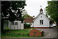
St Christopher's Church, Warlingham
A little timber-framed. weather-boarded building, quite domestic in scale. Though it might easily be mistaken for a non-conformist chapel, it is in fact an Anglican church. It is said to have originated as a mission chapel in the first decade of the 20th century.
The interior - modest in style but more spacious than you might expect - is shown in a contribution by Stephen Craven: http://www.geograph.org.uk/photo/3375735
Image: © Stefan Czapski
Taken: 31 Aug 2018
0.13 miles
7
St Christopher's Church, Warlingham
An unusual building for an Anglican parish church, St Christopher's was built in 1906 and was a Church Army mission until after World War 2. It is a timber building and was extended in the 1960's.
Image: © Stephen Craven
Taken: 7 Mar 2007
0.13 miles
8

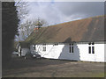
Warlingham, Chelsham Road: Church and community hall
Unusually for a Church of England building, this church is a pleasant weatherboarded structure, showing that good architecture is possible on a very limited budget.
Image: © Dr Neil Clifton
Taken: 1 Jul 2012
0.14 miles
9
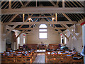
Interior of St Christopher's church
For the exterior of this wooden church, see Image Unusually for such a small, simple building it boasts a pipe organ (left).
Image: © Stephen Craven
Taken: 7 Mar 2007
0.14 miles
10
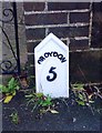
Old Milepost by the B269, Limpsfield Road, Warlingham
Cast iron post by the B269, in parish of WARLINGHAM (TANDRIDGE District), by No. 630 Limpsfield Road, South end of Warlingham, opposite Sainsbury's, back of pavement against brick gate pillar, on South side of road. Croydon gable iron plate, erected by the Limpsfield turnpike trust in the 19th century.
Inscription reads:-
CROYDON
5
(?)
IRON
FOUNDRY
Milestone Society National ID: SY_CYLF05.
Image: © JS Payne
Taken: 1 Oct 2007
0.14 miles