IMAGES TAKEN NEAR TO
Limpsfield Road, WARLINGHAM, CR6 9RL
Introduction
This page details the photographs taken nearby to Limpsfield Road, CR6 9RL by members of the Geograph project.
The Geograph project started in 2005 with the aim of publishing, organising and preserving representative images for every square kilometre of Great Britain, Ireland and the Isle of Man.

There are currently over 7.5m images from over14,400 individuals and you can help contribute to the project by visiting https://www.geograph.org.uk
Image Map
Images are licensed for reuse under creativecommons.org/licenses/by-sa/2.0
Notes
- Clicking on the map will re-center to the selected point.
- The higher the marker number, the further away the image location is from the centre of the postcode.
Image Listing (44 Images Found)
Images are licensed for reuse under creativecommons.org/licenses/by-sa/2.0
Image
Details
Distance
1
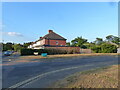
Housing on Church Road at its junction with Dane Road, Warlingham
Image: © Ruth Sharville
Taken: 18 Aug 2022
0.08 miles
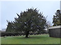
4
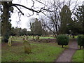
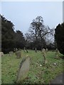
All Saints, Warlingham: churchyard (VIII)
Image: © Basher Eyre
Taken: 30 Jan 2017
0.13 miles
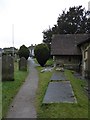
5
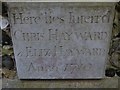
All Saints, Warlingham: external memorial (I)
Image: © Basher Eyre
Taken: 30 Jan 2017
0.13 miles
6
All Saints, Warlingham: churchyard (III)
Image: © Basher Eyre
Taken: 30 Jan 2017
0.13 miles
7
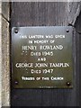
All Saints, Warlingham: external memorial (II)
Image: © Basher Eyre
Taken: 30 Jan 2017
0.13 miles
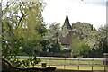
10
All Saints, Warlingham: churchyard (VI)
Image: © Basher Eyre
Taken: 30 Jan 2017
0.13 miles