IMAGES TAKEN NEAR TO
Bramber Way, WARLINGHAM, CR6 9PD
Introduction
This page details the photographs taken nearby to Bramber Way, CR6 9PD by members of the Geograph project.
The Geograph project started in 2005 with the aim of publishing, organising and preserving representative images for every square kilometre of Great Britain, Ireland and the Isle of Man.

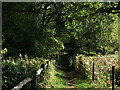
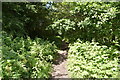
There are currently over 7.5m images from over14,400 individuals and you can help contribute to the project by visiting https://www.geograph.org.uk
Image Map
Images are licensed for reuse under creativecommons.org/licenses/by-sa/2.0
Notes
- Clicking on the map will re-center to the selected point.
- The higher the marker number, the further away the image location is from the centre of the postcode.
Image Listing (36 Images Found)
Images are licensed for reuse under creativecommons.org/licenses/by-sa/2.0
Image
Details
Distance
2
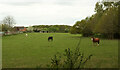
Pasture, Chelsham
From Chelsham Common Road carrying the Vanguard Way. Behind is Littlepark Wood.
Image: © Derek Harper
Taken: 27 Apr 2022
0.08 miles
3
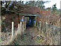
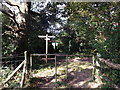
Grade segregation on footpath 93
A curious overbridge on the footpath, and not because of the lie of the land. It carries one of the former drives to the old Croydon Mental Hospital, now an exclusive housing estate. This drive is no longer used, and looks as if it was a sort of tradesman's entrance. The main hospital was to the right and its much smaller isolation hospital was to the left. This segregation of routes is reminiscent of the sort of thing that was engineered in South Africa in the apartheid days.
Image: © Robin Webster
Taken: 30 Jan 2011
0.09 miles
4
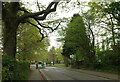
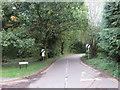
Chelsham Common Road
The road approaches Warlingham Park School. The Vanguard Way turns left just before the narrowing, onto Chelsham & Farleigh footpath 93. Chelsham & Farleigh footpath 2 continues along the private road beyond.
Image: © Derek Harper
Taken: 27 Apr 2022
0.13 miles
5
Vanguard Way to Chelsham
The long distance path heads along a footpath towards East Parkside in Chelsham.
Image: © David Anstiss
Taken: 23 Oct 2011
0.14 miles
6
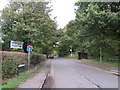
Chelsham Road, near Warlingham
The blue sign to the left indicates that Chelsham Road is a "no through road"
Image: © Malc McDonald
Taken: 20 Oct 2019
0.14 miles
7
Ledgers Road at the junction of Chelsham Road
Image: © David Howard
Taken: 4 Jan 2015
0.14 miles
8
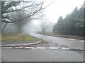
Ledgers Road, near Warlingham
Ledgers Road is a minor road in north east Surrey. The signs indicate that the national speed limit applies beyond this point.
Image: © Malc McDonald
Taken: 20 Oct 2019
0.14 miles
10
Footpath and bridleway junction near Great Park Wood
A footpath (and Vanguard Way) heads from Chelsham to follow a bridleway right to Farleigh. Another bridleway heads left to Daniels Lane. Another footpath heads straight on to Littlepark Wood.
Image: © David Anstiss
Taken: 23 Oct 2011
0.15 miles