IMAGES TAKEN NEAR TO
Homefield Road, WARLINGHAM, CR6 9HQ
Introduction
This page details the photographs taken nearby to Homefield Road, CR6 9HQ by members of the Geograph project.
The Geograph project started in 2005 with the aim of publishing, organising and preserving representative images for every square kilometre of Great Britain, Ireland and the Isle of Man.

There are currently over 7.5m images from over14,400 individuals and you can help contribute to the project by visiting https://www.geograph.org.uk
Image Map
Images are licensed for reuse under creativecommons.org/licenses/by-sa/2.0
Notes
- Clicking on the map will re-center to the selected point.
- The higher the marker number, the further away the image location is from the centre of the postcode.
Image Listing (30 Images Found)
Images are licensed for reuse under creativecommons.org/licenses/by-sa/2.0
Image
Details
Distance
1
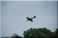
The last Hurricane ever built PZ869
The last Hurricane ever built flew over in the direction of Kenley Aerodrome.
This plane has had a very interesting history.
http://www.raf.mod.uk/bbmf/theaircraft/hurricanepz865.cfm
Image: © patrick connolly
Taken: 29 Jun 2013
0.10 miles
2
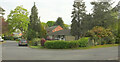
Junction, Warlingham
Butterfly Walk (left) meets Homefield Road.
Image: © Derek Harper
Taken: 28 Apr 2022
0.10 miles
3
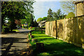
Butterfly Walk, Warlingham
Reaching the junction with Homefield Road on the right; beyond it, Landscape Road continues ahead.
Image: © Derek Harper
Taken: 25 Apr 2022
0.11 miles
4
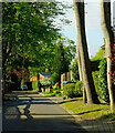
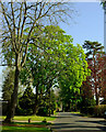
Butterfly Walk, Warlingham
Mature trees dominate the no through road, which leads into Landcape Road.
Image: © Derek Harper
Taken: 25 Apr 2022
0.12 miles
5
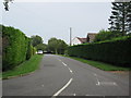
Landscape Road, Warlingham
The southern arm of the road.
Image: © Derek Harper
Taken: 25 Apr 2022
0.13 miles
6
Westhall Park
This road leads of Landscape Road.
Image: © David Anstiss
Taken: 6 Sep 2014
0.13 miles
7
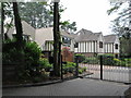
Woodlands and Greensleaves
This pair of fake modern timber-framed houses are on Butterfly Walk.
Image: © David Anstiss
Taken: 6 Sep 2014
0.13 miles
8
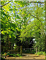
Gate beneath trees, Warlingham
Warlingham bridleway 85 reaches the top of a stiff climb to enter a leafy residential estate. Butterfly Walk is the road ahead, with Windmill Rise on the left.
Image: © Derek Harper
Taken: 25 Apr 2022
0.15 miles
9
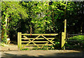
Gate beneath trees, Warlingham
The gate, at the end of Butterfly Walk, is seen from the other side of Image
Image: © Derek Harper
Taken: 25 Apr 2022
0.15 miles
10
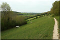
Footpath to Butterfly Walk
Warlingham footpath 39 runs along the valley side; the trees on the left border Bug Hill.
Image: © Derek Harper
Taken: 28 Apr 2022
0.16 miles