IMAGES TAKEN NEAR TO
Daniels Lane, WARLINGHAM, CR6 9ET
Introduction
This page details the photographs taken nearby to Daniels Lane, CR6 9ET by members of the Geograph project.
The Geograph project started in 2005 with the aim of publishing, organising and preserving representative images for every square kilometre of Great Britain, Ireland and the Isle of Man.

There are currently over 7.5m images from over14,400 individuals and you can help contribute to the project by visiting https://www.geograph.org.uk
Image Map
Images are licensed for reuse under creativecommons.org/licenses/by-sa/2.0
Notes
- Clicking on the map will re-center to the selected point.
- The higher the marker number, the further away the image location is from the centre of the postcode.
Image Listing (41 Images Found)
Images are licensed for reuse under creativecommons.org/licenses/by-sa/2.0
Image
Details
Distance
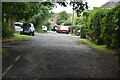
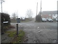
2
Daniels Lane, Farleigh
There was nothing wrong with my camera, it was foggy
Image: © David Howard
Taken: 4 Jan 2015
0.02 miles
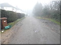
5
Daniels Lane at the junction of Harrow Road
Image: © David Howard
Taken: 4 Jan 2015
0.04 miles
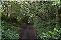
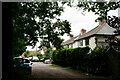
8
Bridleway to Daniel's Lane
This track leads past Littlepark Wood (on the right).
Image: © David Anstiss
Taken: 23 Oct 2011
0.10 miles
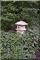
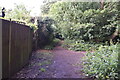
9

Footpath to Littlepark Wood
A field path leads from bridleway near Greatpark Wood, to Littlepark Wood (in the background) and Farleigh Court Road.
Image: © David Anstiss
Taken: 23 Oct 2011
0.10 miles
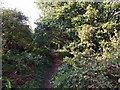
10
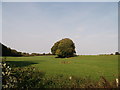
Field near Littlepark Wood
Littlepark Wood is on the left and Greatpark Wood is on the right.
Image: © David Anstiss
Taken: 23 Oct 2011
0.12 miles