IMAGES TAKEN NEAR TO
Bournewood Grove, WARLINGHAM, CR6 9BX
Introduction
This page details the photographs taken nearby to Bournewood Grove, CR6 9BX by members of the Geograph project.
The Geograph project started in 2005 with the aim of publishing, organising and preserving representative images for every square kilometre of Great Britain, Ireland and the Isle of Man.

There are currently over 7.5m images from over14,400 individuals and you can help contribute to the project by visiting https://www.geograph.org.uk
Image Map
Images are licensed for reuse under creativecommons.org/licenses/by-sa/2.0
Notes
- Clicking on the map will re-center to the selected point.
- The higher the marker number, the further away the image location is from the centre of the postcode.
Image Listing (12 Images Found)
Images are licensed for reuse under creativecommons.org/licenses/by-sa/2.0
Image
Details
Distance
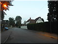
1
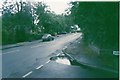
Westhall Road, Warlingham
At the junction with Homefield Road
Image: © Geographer
Taken: Unknown
0.09 miles

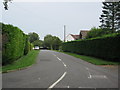
3
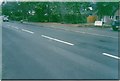
Westhall Road, Warlingham
Near Homefield Road
Image: © Geographer
Taken: Unknown
0.12 miles
6

No planes in the sky
Looking towards Kenley 2 World War airfield not a plane in sight. No jets taking off from Gatwick thanks to volcanic ash in Iceland.Cars next?
Image: © patrick connolly
Taken: 17 Apr 2010
0.19 miles
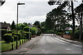
8
Westhall Park
This road leads of Landscape Road.
Image: © David Anstiss
Taken: 6 Sep 2014
0.22 miles
9
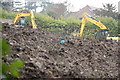
Diggers caught rutting near Warlingham.
It appears if your back yard is big enough you can do what you like. This is going swimmingly well for some.
Image: © patrick connolly
Taken: 11 Feb 2009
0.23 miles
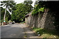
10
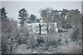
New build
"Everything changes can`t say good or bad". The trees will decide.
Image: © patrick connolly
Taken: 6 Feb 2009
0.24 miles