IMAGES TAKEN NEAR TO
Church Lane Avenue, COULSDON, CR5 3RT
Introduction
This page details the photographs taken nearby to Church Lane Avenue, CR5 3RT by members of the Geograph project.
The Geograph project started in 2005 with the aim of publishing, organising and preserving representative images for every square kilometre of Great Britain, Ireland and the Isle of Man.

There are currently over 7.5m images from over14,400 individuals and you can help contribute to the project by visiting https://www.geograph.org.uk
Image Map
Images are licensed for reuse under creativecommons.org/licenses/by-sa/2.0
Notes
- Clicking on the map will re-center to the selected point.
- The higher the marker number, the further away the image location is from the centre of the postcode.
Image Listing (87 Images Found)
Images are licensed for reuse under creativecommons.org/licenses/by-sa/2.0
Image
Details
Distance
1
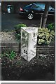
Old Milestone, A23, Brighton Road, Outside No. 99
The milestone is located 120m North of the junction with Church Lane, on the East side of the road in the pavement with back to boundary wall. Parish of Reigate (Reigate and Barnstead District). Cast iron post, Reigate iron casting design, erected by Croydon & Reigate turnpike trust in the 19th century.
Inscription reads:- 16 / FROM / WESTMINSTER / BRIDGE / 35 / TO / BRIGHTON : : 35 / FROM / BRIGHTON / 16 / TO / WESTMINSTER / BRIDGE : : PARISH / OF / MERSTHAM
Milestone Society National ID: SY_LBT16
Image: © Janet Dowding
Taken: Unknown
0.11 miles
2
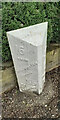
Old Milestone, A23, Brighton Road, Outside No. 99
The milestone is located 120m North of the junction with Church Lane, on the East side of the road in the pavement with back to boundary wall. Parish of Reigate (Reigate and Barnstead District). Cast iron post, Reigate iron casting design, erected by Croydon & Reigate turnpike trust in the 19th century. An earlier photograph can be found here https://www.geograph.org.uk/photo/6955971.
Inscription reads:- 16 / FROM / WESTMINSTER / BRIDGE / 35 / TO / BRIGHTON : : 35 / FROM / BRIGHTON / 16 / TO / WESTMINSTER / BRIDGE : : PARISH / OF / MERSTHAM
Milestone Society National ID: SY_LBT16
Image: © Tony Watson
Taken: 25 Mar 2021
0.11 miles
4
St Margaret's Road, Hooley
You can just see a pre-Worboys sign with the stripy pole taken close here http://www.geograph.org.uk/photo/3122912
Image: © David Howard
Taken: 24 Jan 2016
0.15 miles
5
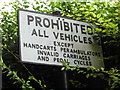
Pre-Worboys sign on St Margaret's Road, Hooley
I have a picture of this already (including the stripy pole) but this is not covered in foliage over one corner.
Image: © David Howard
Taken: 9 Sep 2012
0.16 miles
6
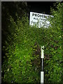
Pre-Worboys sign, Hooley
This has been repainted along with the pole but the hedge has not been kept under control for a while.
Image: © David Howard
Taken: 23 May 2010
0.16 miles
7
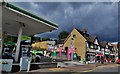
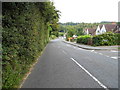
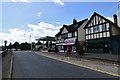
Hooley A23 road: BP Star Lane Service Station
The service station and parade of six shops beyond
Image: © Michael Garlick
Taken: 16 Sep 2013
0.16 miles
9
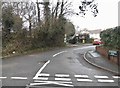
Hooley A23 road: BP Star Lane Service Station
Looking south towards the BP filling station on this, the A23; while there, many motorists clearly exceeded the speed limit on this long, straight section of the Brighton Road; I did not see a single speed camera flash
Image: © Michael Garlick
Taken: 16 Sep 2013
0.17 miles
10
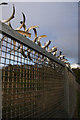
Protection
Fence topping at bridge over railway line
Image: © Kurseong Carl
Taken: 21 Apr 2012
0.17 miles