IMAGES TAKEN NEAR TO
Garden Walk, COULSDON, CR5 3RE
Introduction
This page details the photographs taken nearby to Garden Walk, CR5 3RE by members of the Geograph project.
The Geograph project started in 2005 with the aim of publishing, organising and preserving representative images for every square kilometre of Great Britain, Ireland and the Isle of Man.

There are currently over 7.5m images from over14,400 individuals and you can help contribute to the project by visiting https://www.geograph.org.uk
Image Map
Images are licensed for reuse under creativecommons.org/licenses/by-sa/2.0
Notes
- Clicking on the map will re-center to the selected point.
- The higher the marker number, the further away the image location is from the centre of the postcode.
Image Listing (17 Images Found)
Images are licensed for reuse under creativecommons.org/licenses/by-sa/2.0
Image
Details
Distance
1
Field west of A23
The A23 is behind the hedge on the right.
Image: © Robin Webster
Taken: 21 Nov 2010
0.09 miles
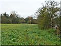
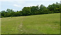
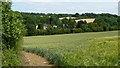
2
View Near Hooley, Surrey
Looking to the east, across the valley which encloses the A23. On the horizon, the old water tower from Netherne Hospital can be seen.
Image: © Peter Trimming
Taken: 4 Jul 2009
0.10 miles
4
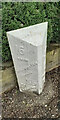
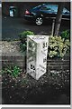
Old Milestone, A23, Brighton Road, Outside No. 99
The milestone is located 120m North of the junction with Church Lane, on the East side of the road in the pavement with back to boundary wall. Parish of Reigate (Reigate and Barnstead District). Cast iron post, Reigate iron casting design, erected by Croydon & Reigate turnpike trust in the 19th century. An earlier photograph can be found here https://www.geograph.org.uk/photo/6955971.
Inscription reads:- 16 / FROM / WESTMINSTER / BRIDGE / 35 / TO / BRIGHTON : : 35 / FROM / BRIGHTON / 16 / TO / WESTMINSTER / BRIDGE : : PARISH / OF / MERSTHAM
Milestone Society National ID: SY_LBT16
Image: © Tony Watson
Taken: 25 Mar 2021
0.12 miles
5
Old Milestone, A23, Brighton Road, Outside No. 99
The milestone is located 120m North of the junction with Church Lane, on the East side of the road in the pavement with back to boundary wall. Parish of Reigate (Reigate and Barnstead District). Cast iron post, Reigate iron casting design, erected by Croydon & Reigate turnpike trust in the 19th century.
Inscription reads:- 16 / FROM / WESTMINSTER / BRIDGE / 35 / TO / BRIGHTON : : 35 / FROM / BRIGHTON / 16 / TO / WESTMINSTER / BRIDGE : : PARISH / OF / MERSTHAM
Milestone Society National ID: SY_LBT16
Image: © Janet Dowding
Taken: Unknown
0.12 miles
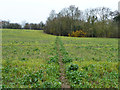
6
Footpath at Hooley, Surrey
The line of the footpath is marked with clover.
Image: © Peter Trimming
Taken: 4 Jul 2009
0.12 miles
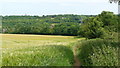
7
Footpath towards Noak Farm, Hogscross Lane
From the A23 opposite the end of Dean Lane.
Image: © Robin Webster
Taken: 21 Nov 2010
0.13 miles
8
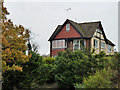
House overlooking A23
Perched high above the A23, with vehicle access at A23 level, this house has good views, and at the bottom of the garden a view down to the northern portal of Merstham Tunnel on the Brighton line.
Image: © Robin Webster
Taken: 21 Nov 2010
0.13 miles
9
View at Hooley, Surrey
Looking across the field to the wooded valley. To the right of picture, hidden amongst the trees, is the A23/M23 junction.
Image: © Peter Trimming
Taken: 4 Jul 2009
0.13 miles
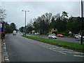
10

Rush Hour
Rush hour traffic northbound on the A23 at Hooley
Image: © Kurseong Carl
Taken: 20 May 2011
0.15 miles