IMAGES TAKEN NEAR TO
Hollymeoak Road, COULSDON, CR5 3QE
Introduction
This page details the photographs taken nearby to Hollymeoak Road, CR5 3QE by members of the Geograph project.
The Geograph project started in 2005 with the aim of publishing, organising and preserving representative images for every square kilometre of Great Britain, Ireland and the Isle of Man.

There are currently over 7.5m images from over14,400 individuals and you can help contribute to the project by visiting https://www.geograph.org.uk
Image Map (Loading...)


Getting Data...Please wait
Leaflet Map data © OpenStreetMap
Images are licensed for reuse under creativecommons.org/licenses/by-sa/2.0
Notes
- Clicking on the map will re-center to the selected point.
- The higher the marker number, the further away the image location is from the centre of the postcode.
Image Listing (20 Images Found)
Images are licensed for reuse under creativecommons.org/licenses/by-sa/2.0
Image
Details
Distance
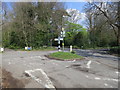
1
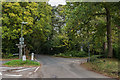
Coulsdon Lane
The junction where Coulsdon Lane becomes Portnalls Road (in the background) and Hollymead Road (on the left) becomes Hollymeoak Road (on the right). Portnalls Road and Hollymeoak Road are in Coulsdon (in the London Borough of Croydon) whereas as Coulsdon Lane and Hollymead Road are in Chipstead (in Surrey), hence the cast iron Coulsdon sign on the left. To its right is a coal tax post (no 162 in the list linked to below). For a close up of the coal tax post see Image and of the coal tax post and Coulsdon sign see Image
Image: © Ian Capper
Taken: 27 Oct 2018
0.06 miles
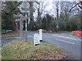
2
Coal tax post no 162
This coal tax post (no 162 on the list linked to below) is situated at the junction Coulsdon Lane/Portnalls Road with Hollymead Road/Hollymeoak Road. For wider views see Image and Image
Image: © Ian Capper
Taken: 27 Oct 2018
0.07 miles
3
Coal tax post no 162
This coal tax post (no 162 on the list linked to below) is situated at the junction of Coulsdon Lane/Portnalls Road with Hollymead Road/Hollymeoak Road. Coulsdon (in the London Borough of Croydon) meets Chipstead (in Surrey) here, hence the cast iron Coulsdon sign. In the background is Rickman Hill Road. For a close up of the coal tax post see Image and for a wider view see Image
Image: © Ian Capper
Taken: 27 Oct 2018
0.07 miles
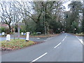
4
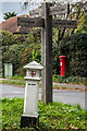
Chipstead Signpost
Signpost and Rural District boundary marker together.
Image: © Peter Trimming
Taken: 27 Jan 2009
0.07 miles
6
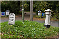
Road junction near Chipstead
A crossroads near Chipstead. The junction is at the boundary of Surrey and Greater London. The foreground is in Surrey, as are the road heading off to the left and the lane behind the wooden signpost. The road heading straight ahead enters Greater London as it leaves the junction as does the turning to the right.
To the left of the image are a marker for the Coulsdon rural district, along with a coal tax post.
Image: © Malc McDonald
Taken: 11 Jan 2020
0.07 miles
7
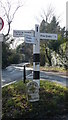
Posts and markers near Chipstead
A wooden signpost giving directions, a coal tax post and a marker at a road junction near Chipstead. This point is at the boundary between Greater London and Surrey. The foreground is in Surrey while the roads heading away from the camera both enter Greater London as hey leave the junction.
Image: © Malc McDonald
Taken: 11 Jan 2020
0.07 miles
9
Dorrington
House on Rickman Hill Road. Although its neighbours appear on the 1935 1:2,500 map, this site is shown as an empty plot. It is however shown on the 1959-71 edition.
Image: © Ian Capper
Taken: 27 Oct 2018
0.13 miles
10
Willow Tree Cottage
Thatched house on Rickman Hill Road next to where it is met by Bouverie Road, first shown on the 1935 1:2,500 map.
Image: © Ian Capper
Taken: 27 Oct 2018
0.14 miles