IMAGES TAKEN NEAR TO
Starrock Lane, COULSDON, CR5 3QD
Introduction
This page details the photographs taken nearby to Starrock Lane, CR5 3QD by members of the Geograph project.
The Geograph project started in 2005 with the aim of publishing, organising and preserving representative images for every square kilometre of Great Britain, Ireland and the Isle of Man.

There are currently over 7.5m images from over14,400 individuals and you can help contribute to the project by visiting https://www.geograph.org.uk
Image Map
Images are licensed for reuse under creativecommons.org/licenses/by-sa/2.0
Notes
- Clicking on the map will re-center to the selected point.
- The higher the marker number, the further away the image location is from the centre of the postcode.
Image Listing (16 Images Found)
Images are licensed for reuse under creativecommons.org/licenses/by-sa/2.0
Image
Details
Distance
1
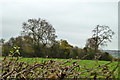
Over the hedge from Chipstead Meads recreation ground
Behind the trees are some large barns, curiously still not mapped although they have been there for several years.
Image: © Robin Webster
Taken: 21 Nov 2010
0.10 miles
2
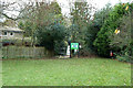
A way out from Chipstead Meads recreation ground
In the extreme north corner, to Starrock Lane.
Image: © Robin Webster
Taken: 21 Nov 2010
0.13 miles
3
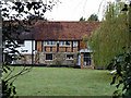
Palmer's Cottage, rear view
Clearly mostly of some age, it looks like a row of cottages, but Victorian maps suggest it was only one dwelling in those times.
Image: © Robin Webster
Taken: 21 Nov 2010
0.13 miles
4
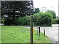
Public Footpath, near Starrock Wood
This footpath leads to Starrock Wood, behind the houses seen in the photograph
Image: © Hywel Williams
Taken: 11 Jul 2005
0.14 miles
5
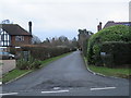
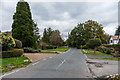
Coulsdon Lane
Old country lane later built on as Chipstead expanded, with development first shown on the 1935 1:2,500 map.
Image: © Ian Capper
Taken: 27 Oct 2018
0.14 miles
6
Private road in Chipstead
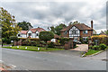
A private road in the village of Chipstead in north Surrey.
Image: © Malc McDonald
Taken: 11 Jan 2020
0.14 miles
7
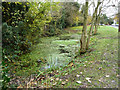
Pond, Chipstead
By Starrock Lane on a scrap of village green.
Image: © Robin Webster
Taken: 21 Nov 2010
0.15 miles
8
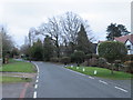
Coulsdon Lane, Chipstead
A view along Coulsdon Lane in the village of Chipstead, in north Surrey. This image was taken on a dull afternoon in January, not long before dusk.
Image: © Malc McDonald
Taken: 11 Jan 2020
0.15 miles
9
Coulsdon Lane
Old country lane later built on as Chipstead expanded, with development first shown on the 1935 1:2,500 map.
Image: © Ian Capper
Taken: 27 Oct 2018
0.16 miles
10
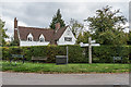
Cladagh
House on the Coulsdon Lane/High Road/How Lane/Doghurst Lane staggered crossroads, first appearing on the 1935 1:2,500 map.
Image: © Ian Capper
Taken: 27 Oct 2018
0.17 miles