1
Woodmansterne Water Treatment Works dated 1907
Image: © tristan forward
Taken: 31 Jan 2011
0.07 miles
2
Woodmansterne Pumping Station
At least this is what the inscription says over the doorway "THE SUTTON DISTRICT WATER COMPANY: WOODMANSTERNE PUMPING STATION". The date in the roof gable is 1907. The building now belongs to Sutton and East Surrey Water and is part of Woodmansterne Treatment Works.
Image: © Marathon
Taken: 14 Aug 2013
0.08 miles
3
Lackford Road, Chipstead
The junction with the main Outwood Lane is just ahead.
Image: © Marathon
Taken: 14 Aug 2013
0.10 miles
4
Outwood Lane at the junction of Rectory Lane, Woodmansterne
Image: © David Howard
Taken: 15 Jun 2014
0.11 miles
5
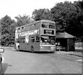
Chipstead Valley (Mid Day Sun) bus terminus
For many years the western terminus of Route 166, but around 2000 this route was extended further west to Banstead, and later Epsom, so that this is no longer a terminus. At the same time, double deckers ceased to be used. This shows vehicle M930.
Image: © Dr Neil Clifton
Taken: 25 Aug 1998
0.12 miles
6
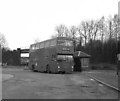
Chipstead Valley bus terminus (2)
A DMS class bus at its dedicated stand at the Chipstead Valley terminus, outside the 'Mid Day Sun'. This was the last day of the 166A Sunday working. The blind reads 'East Croydon, Gordon Arms'.
Image: © Dr Neil Clifton
Taken: Unknown
0.12 miles
7
Chipstead Valley bus terminus
For many years, bus route 166 had its western terminus here, outside the 'Midday Sun' public house.
Image: © Dr Neil Clifton
Taken: 25 Aug 1998
0.13 miles
8
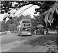
Chipstead Valley bus terminus
For many years, Route 166 terminated here, outside the Mid Day Sun public house (to the left of the photographer). As this photograph was taken on a Sunday, the route number shown by the bus is 166A, because on Sundays the other end of the route was at a different place from the usual Monday to Saturday working. In the background here is seen the bridge carrying the Tattenham Corner branch railway over the B2032 road. In the last few years, Route 166 has been altered and now runs through to Banstead or Epsom; it is now worked with single-deckers. However, the buses still pull in to this old off-road terminal point in both directions
Image: © Dr Neil Clifton
Taken: 12 Jun 1983
0.13 miles
9
Chipstead Way, Woodmansterne
Image: © David Howard
Taken: 14 Jan 2013
0.15 miles
10
Woodmansterne Primary School sign
This was the photographer's first school, back in the mid fifties, when he lived on the Smallholdings. He had a walk of some 25 minutes there and back, in all weathers, including snow.
Image: © JOHN PARKIN
Taken: 11 Oct 2009
0.15 miles


