
IMAGES TAKEN NEAR TO
Outwood Lane, COULSDON, CR5 3NF
Introduction
This page details the photographs taken nearby to Outwood Lane, CR5 3NF by members of the Geograph project.
The Geograph project started in 2005 with the aim of publishing, organising and preserving representative images for every square kilometre of Great Britain, Ireland and the Isle of Man.

There are currently over 7.5m images from over14,400 individuals and you can help contribute to the project by visiting https://www.geograph.org.uk
Image Map
Images are licensed for reuse under creativecommons.org/licenses/by-sa/2.0
Notes
- Clicking on the map will re-center to the selected point.
- The higher the marker number, the further away the image location is from the centre of the postcode.
Image Listing (70 Images Found)
Images are licensed for reuse under creativecommons.org/licenses/by-sa/2.0
Image
Details
Distance
1
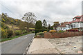
Outwood Lane
Looking north along Outwood Lane. In the background is a coal tax post (no 159 on the list linked to below). For a close up see Image
Image: © Ian Capper
Taken: 27 Oct 2018
0.02 miles
2
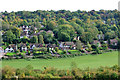
Houses and trees, Chipstead Valley
Outwood Lane follows the valley bottom.
Image: © Robin Webster
Taken: 6 Oct 2010
0.03 miles
3

Coal tax post no 159
This coal tax post (no 159 on the list linked to below) is situated on the side of Outwood Lane. For wider views see Image and Image
Image: © Ian Capper
Taken: 27 Oct 2018
0.04 miles
4
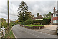
Outwood Lane
Looking north along Outwood Lane. On the left is a coal tax post (no 159 on the list linked to below). For a close up see Image
Image: © Ian Capper
Taken: 27 Oct 2018
0.04 miles
5
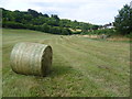
Chipstead Bottom
Outwood Lane has no pavements through the stretch between here and Hazelwood Lane so it is handy to have a tarmac footpath through Chipstead Bottom on the other side of the hedge from Outwood Lane. The path can be seen to the right here and there are a number of access gates to reach the houses in Outwood Lane. One of these gates can be seen ahead. The edge of Banstead Wood is on the left.
Image: © Marathon
Taken: 14 Aug 2013
0.04 miles
6
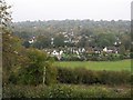
Houses in Chipstead valley
Taken from the same spot as Image, this view looks directly across the valley. The B2032, Outwood Lane, runs up the foot of the dry valley below the downs. The next road behind is Old Oak Avenue.
Image: © Derek Harper
Taken: 12 Oct 2007
0.05 miles
7
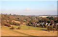
Chipstead Downs
Open access downland, owned by Surrey County Council, above Outwood Lane. Note the new fencing (along Outwood Lane and on the slopes above) to facilitate grazing.
Image: © Hugh Craddock
Taken: 28 Dec 2008
0.05 miles
8
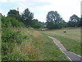
Chipstead Bottom
Outwood Lane has no pavements through the stretch between here and Hazelwood Lane so it is handy to have a tarmac footpath through Chipstead Bottom on the other side of the hedge from Outwood Lane.
Image: © Marathon
Taken: 14 Aug 2013
0.06 miles
9
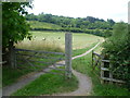
Chipstead Bottom looking up to Banstead Wood
Outwood Lane has no pavements through the stretch between here and Hazelwood Lane so it is handy to have a tarmac footpath through Chipstead Bottom on the other side of the hedge from Outwood Lane.
Image: © Marathon
Taken: 14 Aug 2013
0.07 miles
10
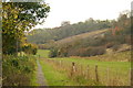
Footpath in Chipstead Valley
The path keeps walkers away from the busy lane, which is just the other side of the hedge, to the left of picture.
Image: © Peter Trimming
Taken: 30 Oct 2009
0.10 miles