IMAGES TAKEN NEAR TO
Iron Railway Close, COULSDON, CR5 3LR
Introduction
This page details the photographs taken nearby to Iron Railway Close, CR5 3LR by members of the Geograph project.
The Geograph project started in 2005 with the aim of publishing, organising and preserving representative images for every square kilometre of Great Britain, Ireland and the Isle of Man.

There are currently over 7.5m images from over14,400 individuals and you can help contribute to the project by visiting https://www.geograph.org.uk
Image Map
Images are licensed for reuse under creativecommons.org/licenses/by-sa/2.0
Notes
- Clicking on the map will re-center to the selected point.
- The higher the marker number, the further away the image location is from the centre of the postcode.
Image Listing (136 Images Found)
Images are licensed for reuse under creativecommons.org/licenses/by-sa/2.0
Image
Details
Distance
1
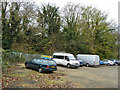
Old railway embankment, Coulsdon
One of the few remains of the Croydon, Merstham and Godstone Railway, a horse-drawn plateway dating from 1805. It never got as far as Godstone. It expired in 1838 when the true railway age arrived, being bought out and partly built on by the London and Brighton Railway. This embankment was needed to cross the Chipstead Valley, the embankment once continued to the right, where there was bridge over the road.
Image: © Robin Webster
Taken: 21 Nov 2010
0.03 miles
2
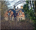
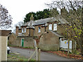
Former farmhouse, Coulsdon
Seemingly part of Coulsdon Area Farm, improbably a working farm but with an uncertain future in light of the wholesale redevelopment of the adjacent Cane Hill Hospital site.
Image: © Stephen Richards
Taken: 21 Jan 2017
0.05 miles
3
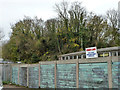
Old railway embankment, Coulsdon
One of the few remains of the Croydon, Merstham and Godstone Railway, a horse-drawn plateway dating from 1805. It never got as far as Godstone. It expired in 1838 when the true railway age arrived, being bought out and partly built on by the London and Brighton Railway. This embankment was needed to cross the Chipstead Valley, the embankment once continued to the right, where there was bridge over the road.
Image: © Robin Webster
Taken: 21 Nov 2010
0.06 miles
5
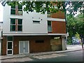
6 new flats, Lion Green Road / Brighton Road
Image: © Alex McGregor
Taken: 7 Jul 2010
0.09 miles
7
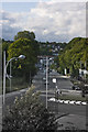
Northbound
Looking down at the town from the Coulsdon by-pass
Image: © Kurseong Carl
Taken: 18 Jun 2011
0.10 miles
8
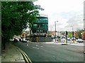
Roundabout on Brighton Road, Coulsdon
At the junction of the A23 seen crossing on the flyover
Image: © David Howard
Taken: 17 Nov 2013
0.10 miles
9
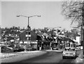
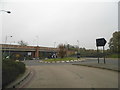
Brighton Road, Coulsdon, at the junction of Lion Green Road (A237)
It's New Year's Day 1979, and there has been snow.
Image: © Dr Neil Clifton
Taken: 1 Jan 1979
0.10 miles
10
House on Fourth Drive
Or possibly two houses, one boarded up. Main access seems to be from the other side.
Image: © Robin Webster
Taken: 21 Nov 2010
0.10 miles