IMAGES TAKEN NEAR TO
Rickman Hill, COULSDON, CR5 3DP
Introduction
This page details the photographs taken nearby to Rickman Hill, CR5 3DP by members of the Geograph project.
The Geograph project started in 2005 with the aim of publishing, organising and preserving representative images for every square kilometre of Great Britain, Ireland and the Isle of Man.

There are currently over 7.5m images from over14,400 individuals and you can help contribute to the project by visiting https://www.geograph.org.uk
Image Map
Images are licensed for reuse under creativecommons.org/licenses/by-sa/2.0
Notes
- Clicking on the map will re-center to the selected point.
- The higher the marker number, the further away the image location is from the centre of the postcode.
Image Listing (38 Images Found)
Images are licensed for reuse under creativecommons.org/licenses/by-sa/2.0
Image
Details
Distance
1
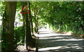
Portnalls Road - Steep Hill 1:8
Portnalls Road, Coulsdon. 1:8 steep hill down sign.
Image: © Adam Morse
Taken: 11 Jun 2009
0.12 miles
2
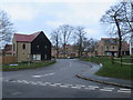
Sir James Moody Way, Coulsdon
Sir James Moody Way forms part of a new housing development in Coulsdon, on the outer fringe of south London. The housing development is on the site formerly occupied by a hospital.
Image: © Malc McDonald
Taken: 11 Jan 2020
0.14 miles
3
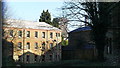
Cane Hill Asylum, Coulsdon, Surrey
Looking across the site, in the direction of the water tower, during demolition; January 2009.
http://en.wikipedia.org/wiki/Cane_Hill
Image: © Peter Trimming
Taken: 27 Jan 2009
0.15 miles
4
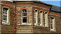
Cane Hill Asylum, Coulsdon, Surrey
During demolition in January 2009, detail of the remaining terracotta tiles around the windows.
http://en.wikipedia.org/wiki/Cane_Hill
Image: © Peter Trimming
Taken: 27 Jan 2009
0.16 miles
5
Cane Hill Asylum, Coulsdon
The attractive terracotta tiles have been removed prior to demolition. Tile fragments have accumulated at the base of the building.
Image: © Peter Trimming
Taken: 27 Jan 2009
0.17 miles
7
Cane Hill Asylum
Looking towards the water tower of Cane Hill Asylum. The hospital opened in two phases, in 1882 and in 1888 as the Third Surrey County Lunatic Asylum.
Demolition of Cane Hill started in March 2008 and was completed by the end of 2010. Only the Chapel, Administration building and Water Tower remained.
On 13 November 2010 a fire took hold in the administration block and went on to destroy all but the front facade of the building. The fire also destroyed the iconic clock tower.
Image: © Peter Trimming
Taken: 6 Nov 2014
0.18 miles
8
Woodlands Grove, Woodmansterne
The suburban part of Woodmansterne here is part of Coulsdon in London, which ends just behind this view and becomes the rural part in Surrey, accessible from a path here http://www.geograph.org.uk/photo/3295791
Image: © David Howard
Taken: 14 Jan 2013
0.18 miles
9
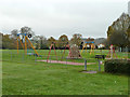
Play area, Rickman Hill
In the corner of the recreation ground. The play area is rather bigger than the view shows, with further apparatus to the right.
Image: © Robin Webster
Taken: 21 Nov 2010
0.18 miles
10
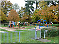
Play area, Rickman Hill
In the corner of the recreation ground. The play area is rather bigger than the view shows, with further apparatus to the left, including a cableway.
Image: © Robin Webster
Taken: 21 Nov 2010
0.19 miles